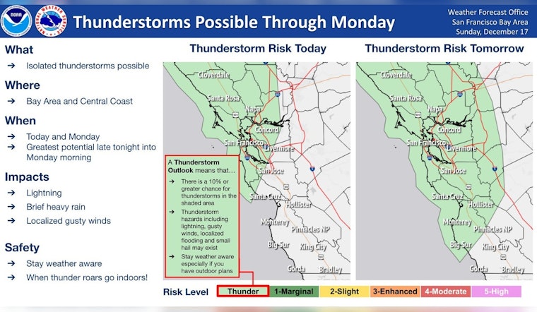
The Bay Area is bracing for a series of stormy conditions as the National Weather Service announces two rounds of rainfall and the potential for thunderstorms. The first bout opened the skies this morning, and a stronger wave is expected to surge tonight into Monday, bringing gusty winds along with it. As per the NWS Bay Area's caution, residents are reminded to remain vigilant and remember, "When thunder roars go indoors! #cawx" according to a statement obtained by the NWS Bay Area.
Two rounds of rain on the way. First arriving this morning with the second, stronger, round late tonight into Monday. Gusty winds and a few thunderstorms may accompany tonight's activity. Stay weather aware and remember when thunder roars go indoors! #cawx pic.twitter.com/eSFrtwnle8
— NWS Bay Area 🌉 (@NWSBayArea) December 17, 2023
Showers, pegged at a 60% chance, have been spotted mostly before noon today with new rainfall measurements projecting to rise under a tenth of an inch. Tonight's forecasted thunderstorms are looking to increase precipitation amounts significantly, landing somewhere between a quarter and half of an inch, as the East wind picks up its pace to 7 mph, slated to shift north-northeast come evening. A detailed forecast from weather.gov also predicts continued showers and possible thunderstorms post-dawn on Monday, with gusts powering up to as high as 24 mph. This weather trend is set to intensely rain down throughout the week, potentially adding up to 3 inches in total accumulation by week's end.
As cited by Area Forecast Discussion, a gale force low-pressure system lurks about 780 miles west-southwest of San Francisco, driving the precipitation pattern over the Bay Area. While the heaviest downpours are anticipated early Monday, the discussion mentions the uncertain nature of pinpointing the stronger showers, which could range anywhere from the North Bay to the mountains of Santa Cruz and Monterey Counties. This uncertainty stems from the convective nature of the weather system at play, which will be fully realized in radar view Sunday night.
Marine conditions are also under watch. Mariners have been advised to take caution or remain docked due to a series of advisories and warnings issued by the National Weather Service. The URGENT - Marine Weather Message alerts of isolated thunderstorms this morning across local waters carrying primary threats like lightning and gusty winds. A small craft advisory is now in effect from the afternoon to Monday morning, followed by a gale warning from Monday morning through Monday evening. These forecasts impact various zones across the California coast, from Monterey Bay to just beyond Point Reyes, with sea conditions predicted to be turbulent and hazardous for mariners.
Residents and mariners alike have been urged to stay prepared and consider safety measures in advance, adjusting their plans in light of the oncoming weather onslaught. The overall message from the National Weather Service is one of alertness and readiness as the Bay Area gears up to weather this storm.


