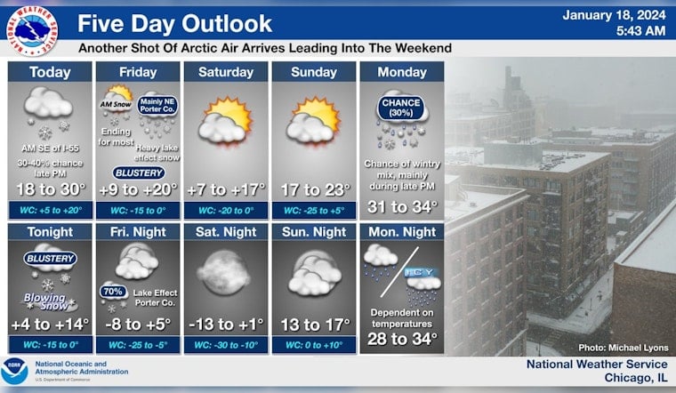
Chicago is bracing for severe winter conditions as the National Weather Service in Chicago/Romeoville issued a hazardous weather outlook, warning of significant snow and blowing snow risk for Thursday and extreme snow risk in northeast Porter County for Friday. Commuters encountered slippery roads and traffic delays early this morning due to a fresh blanket of snow, and a winter storm warning is set to take effect tonight, signaling even more disruptive weather to come.
According to a report by NBC 5, parts of Northwest Indiana could receive up to a foot of snow before the system moves out. The snowfall is expected to begin intensifying around 5 pm tonight, with the brunt of the storm hitting after dark and continuing into the early hours of Friday. In Northeast Illinois, snow accumulation of 2 to 4 inches is predicted, while "pure whiteout conditions" are expected over northeast Porter County, prompting officials to advise against travel in the area.
The frigid conditions are further complicated by high winds, with gusts reaching 30-40 miles per hour, which can cause snow to drift and reduce visibility on the roads to dangerous levels. "For northeast Porter County, travel is expected to become extremely dangerous, if not impossible in spots late tonight into Friday morning," the National Weather Service warned. The service also cautioned that ice jam flooding would continue along some rivers.
Beyond the snowfall, the Chicago area faces a deep freeze with temperatures anticipated to plummet, prompting the National Weather Service to declare an elevated to significant excessive cold risk from Friday through Sunday. Wind chill is expected to drop as low as -9 degrees Fahrenheit. The frigid weather is part of a broader system that has put small craft at risk on Lake Michigan due to hazardous conditions, including dangerous freezing spray.
As Chicagoans bundle up against eyewatering gusts and treacherous ice, there is a glimmer of hope on the horizon. NBC 5's Meteorologist Alicia Roman predicts that by next week, temperatures will climb to warmer levels with a forecast in the 30s and possibly the 40s. A mix of rain and snow is expected Monday, transitioning to likely rain or freezing rain on Tuesday, with chances of rain extending through Wednesday.


