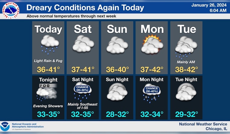
Chicago residents are bracing for patchy drizzle and areas of fog as temperatures hover in the upper 30s. According to the National Weather Service, there's a chance of rain before noon and then again after noon, with cloudy skies and a high near 38 degrees anticipated for today. Fog that might become dense at times is also expected to blanket the city both today and into the night.
As the much-needed rain ends overnight, the city is looking at lows in the mid-30s with the potential for patchy fog to redevelop, per NBC Chicago. Come Saturday, the forecast suggests a continuation of cloudy skies, with temperatures approaching 40 degrees and winds from the north at 5 to 10 mph - a slight reprieve from the dampness for Chicagoans.
The weather also brings some risks, as highlighted by the National Weather Service's Hazardous Weather Outlook. Areas of dense fog may linger into Saturday morning, posing visibility issues for travelers. Furthermore, river rises are a concern over the next several days due to recent rains and snow melt, coupled with the potential break up of existing ice cover, as informed on the National Weather Service's website.
Adding to the city's woes, there's a possibility of more flooding along the Kankakee River near Wilmington due to ice jams breaking up. While "hazardous conditions for small craft are likely" on Sunday and again by midweek, a brief period of partly sunny skies will offer a meager respite Monday, with highs inching toward the low 40s, according to Chicago's Weather Forecast.
Chicagoans should be prepared for a potential chance of rain after midnight on Monday and before noon on Tuesday, as clouds continue to dominate the skies. To cap off the week, predictions hint at mostly sunny conditions by Thursday with a high near 43 degrees, offering Chicago residents a slice of hope for clearer skies ahead.


