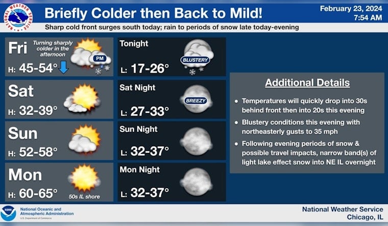
Chicagoans are gearing up for a mix of unpredictable weather entering the weekend. Today's temperate rise is set to plummet, transitioning from a light drizzle to a snowstorm, as the city braces itself for this quick change. The National Weather Service Chicago/Romeoville IL has warned that snowfall is likely before midnight followed by a chance of snow showers, mainly between midnight and 3 am tonight. The cold is predicted to be biting with lows around 26 degrees and strong gusts of wind, increasing up to 35 mph.
Travelers are advised to exercise caution as slippery conditions may develop, primarily on bridges and overpasses. The National Weather Service Chicago posted, "Where snow is still falling w/temps in 20s this eve., some roads may become slick, particularly bridges & overpasses." A 40% chance of precipitation is forecast for the area before the storm gives way to clearer skies Saturday afternoon. Snow accumulation of less than one inch is possible.
Rain behind a strong cold front this afternoon will quickly change to snow into this eve. as temps plummet. Where snow is still falling w/temps in 20s this eve., some roads may become slick, particularly bridges & overpasses in blue shaded areas on map. Stay tuned! #ILwx #INwx pic.twitter.com/xHPwBGsWke
— NWS Chicago (@NWSChicago) February 23, 2024
The weather forecast for the ensuing week predicts a rollercoaster of temperature highs and lows, coupled with the possibility of thunderstorms by next Tuesday. According to the National Weather Service, Tuesday could see temperatures skyrocketing to near 66 degrees, with showers and thunderstorms likely in the afternoon, carrying into a breezy night.
Waterfront activities will also face disruptions. The Hazardous Weather Outlook reports hazardous conditions for small craft on Lake Michigan beginning today and likely extending over the next several days. By Tuesday, gale-force winds and hazardous waves are expected to make marine conditions particularly treacherous. Boaters and beachgoers should stay alert to the evolving conditions and exercise increased caution on and near the water.


