Chicagoans are in for a see-saw of temperatures, with a Spring-like thaw on the horizon following a brisk Saturday. Forecasts call for sunny skies today with a high near 30, which will then plunge tonight to a low around 25, as reported by the National Weather Service. Winds may show their gusty side, reaching up to 35 mph in the evening.
Despite the nippy night, sailors on the Great Lakes should brace themselves for "gale force winds and or very hazardous waves," according to the weather outlook. The rest of the region, however, can look forward to a calm week weather-wise, with "no hazardous weather is expected at this time," the National Weather Service Chicago/Romeoville IL predicts.
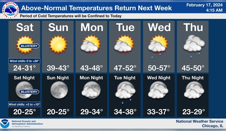
Looking ahead, the mercury is set to rise, with a high near 42 on Sunday, then climbing steadily, reaching towards the upper 40s by Tuesday, and peaking at 51 come Wednesday. The city will experience early hints of Spring as above-normal temperatures return next week, announces the National Weather Service on X. This pattern of warm air is expected to linger, setting the stage for a potentially milder close to February and a balmy beginning to March.
After a relatively chilly Saturday, temperatures will once again climb to above the normal for this time of year with 50 degree readings by the middle of next week. The next chance of precipitation is on Thursday (~20% chance) #ILwx #INwx pic.twitter.com/w8YjfpCsz2
— NWS Chicago (@NWSChicago) February 17, 2024
However, it won't be all sunshine and high temperatures, as Chicago might see signs of winter’s persistence with "brief shots of cool air," especially towards the end of the week when temperatures dip again near Friday. A slight chance of precipitation looms on Thursday, marked at about a 20% chance, so says the Twitter handle of the NWS Chicago. But don't pack away the winter gear just yet, as the city will be reminded of the season's chill, ushering a high near 37 by Friday.


