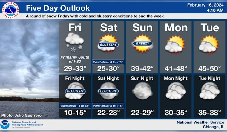
Chicagoans are advised to bundle up and stay weather-aware as the city braces for a slight chance of snow today and a potentially hazardous conditions throughout the weekend. The National Weather Service Chicago/Romeoville IL warns of a "Limited Snow Risk" today, mainly south of Interstate 80, where untreated roads could quickly become slippery, as per their Hazardous Weather Outlook. Gusty northwest winds could also make travel challenging.
The detailed forecast anticipates the slight snow showers to swiftly transition to cloudy skies with daytime highs hovering near the freezing mark. As nighttime falls, temperatures are predicted to plummet to around 14 degrees, with wind chill values dipping as low as zero, hinting at a frigid night ahead.
Looking towards the weekend, sunny skies are to be expected despite the brisk conditions, with Saturday's wind chill potentially falling below zero due to breezy west winds. The clear trends are set to continue into the start of the week, culminating in a mostly sunny Washington's Birthday with highs predicted in the low 40s, according to the Weather Service's prediction.
Boaters should take note of the advisory which indicates "hazardous conditions for small craft" on Lake Michigan, especially east of Gary. The outlook, extending into next week, suggests a reprieve with "pleasant warm up early next week" after a "windy and chilly weekend," as highlighted in a post from NWS Chicago. The Weather Service is also proactively increasing its storm spotter training sessions to enhance community preparedness and response to severe weather events.
Snow will fall on parts of the area today, mainly south of I-80. As many as a couple to a few inches of accumulation are expected south of the US Rt 24 corridor. A windy and chilly weekend will then precede a pleasant warm up early next week. #ILwx #INwx pic.twitter.com/mo1kfZ43OU
— NWS Chicago (@NWSChicago) February 16, 2024
Residents should stay tuned to local forecasts and be prepared to adjust their plans accordingly as the weather changes. With some snow accumulation expected today, especially in areas south of US Rt 24 corridor, and the threat of gale-force winds on Saturday, it's crucial to stay informed on the latest conditions. Despite the winter grip, a warming trend seems just on the horizon, signaling a transient yet steadfast shift toward the spring season.


