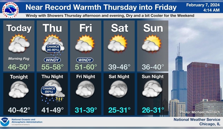
Chicagoans are bracing for a rollercoaster of weather this week with the National Weather Service forecasting unseasonably high temperatures and gusty winds while cautioning commuters about fog-related hazards. According to Chicago's weather forecast, today will see mostly cloudy skies with a high near 47 degrees and winds from the south at 5 to 10 mph.
Tonight, the clouds linger with chilly breezes as lows hover around 42, accompanied by winds intensifying to 10 to 15 mph, gusts may reach up to 20 mph. The Hazardous Weather Outlook issued early this morning warns of "Significant Fog Risk," with areas of dense fog persisting through the morning, particularly across northern Illinois' interiors. Freezing temperatures might create, slippery conditions on untreated surfaces.
The midweek respite comes with a catch as Thursday promises a 50 percent chance of showers and even higher temperatures peaking near 54—but this warmth brings with it breezy conditions. South winds will whip up to 15 to 25 mph, with gusts potentially reaching a blustery 35 mph. The weather service also indicates a "Limited Thunderstorm Risk" for the day, which extends into the night with a 40 percent chance of showers and thunderstorms until midnight.
As we head into the weekend, a sharp contrast emerges. Friday is expected to be sunny with a high of 54 degrees, but following night temperatures dip to 36 degrees, indicating a significant drop. Over the weekend, temperatures will cool further, culminating in daytime highs barely cresting the low 40s, and continuing into next week, according to the forecast. The National Weather Service also notes, that "Hazardous conditions for small craft are likely" on Thursday and Friday, so mariners on Lake Michigan should proceed with caution.
Unseasonably mild weather is expected thru the end of the work week, before conditions cool this weekend. Windy conditions (gusts to 40 mph) are expected Thu PM and eve, along with a chance for showers and thunderstorms. #ILwx #INwx pic.twitter.com/lOLaHVnF7U
— NWS Chicago (@NWSChicago) February 7, 2024
Local meteorologists have turned to social media to advise residents. A post from NWS Chicago discusses the "near record warmth" expected through Friday and cautions against slick spots in the morning due to temperatures hovering near the freezing point. This flux of conditions exemplifies the volatile nature of early spring weather in the Midwest, where residents routinely juggle umbrellas with ice scrapers and sun hats with scarves, sometimes all within the same 24-hour cycle.


