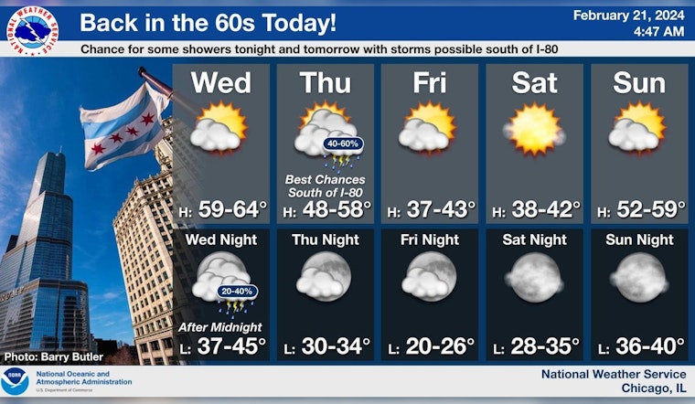
Chicagoans are bracing for a seesaw of temperatures alongside a cocktail of thunderstorms and sunny skies. After a taste of warmth with today's temperature climbing to a mild 61 degrees, the city faces the prospect of stormy weather, including a 20 percent chance of showers after midnight and possible hail up to quarter size, the National Weather Service Chicago/Romeoville issues a Hazardous Weather Outlook alerting residents south of Interstate 80, in particular, to be aware of the limited thunderstorm and hail risks tonight.
As the NWS details anticipated conditions, there's a 40 percent chance of morning showers for Thursday followed by mostly cloudy skies and highs dipping to the upper 40s, yet the night should turn mostly clear overnight with temperatures dropping into the mid-30s, while Friday won't escape the chilly grip entirely with partly sunny skies and a forecast high near 39 degrees; the weekend promises respite from the rain with sunny and partly cloudy conditions, yet a modest high near 38 on Saturday is expected, according to the detailed forecast.
The outlook isn't set to improve for waterborne ventures either, as the weather service forewarns of likely hazardous conditions for small craft from Friday through Sunday and again on Monday night and Tuesday alongside thunderstorm risks, to affect the Illinois and Indiana nearshore waters of Lake Michigan as gleaned from their advisory.
A glimpse into next week provided by a post from NWS Chicago projects a return to milder weather with forecasts suggesting 50s and 60s are on the horizon early on after the city endures a brief cooling phase to kick off the weekend, and while the temperatures retreat, showers are predicted to likely unfold come Tuesday accompanying a breezy high near 63.


