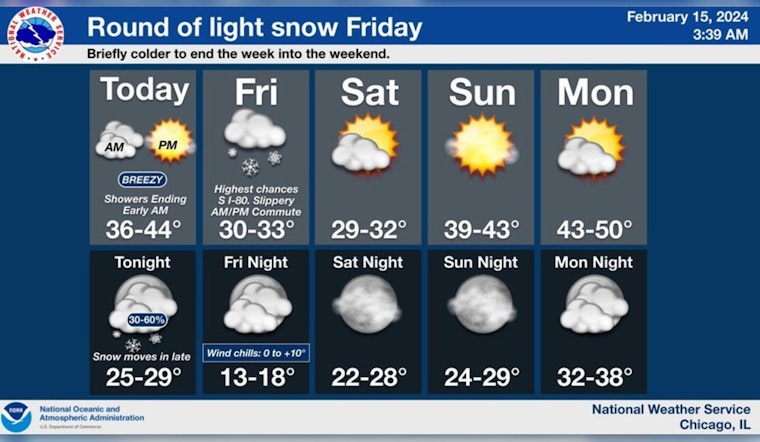
As Chicago braces for an incoming spell of wintry weather, locals are advised to prepare for a drop in temperature and breezy conditions that could lead to hazardous travel. According to the National Weather Service's forecast, today will see a clearing of cloudy skies by mid-morning, with a significant temperature fall to around 37 degrees by the late afternoon. The gusts, as reported by NWS, could reach as high as 35 mph due to a transitioning west-southwest to northwest wind.
Tonight's forecast suggests a slight chance of flurries after 3 am, and a drop in temperature to around 28 degrees, with northnorthwest winds blowing between 10 to 15 mph. Following tonight's lull, Friday is expected to bring a chance of snow before noon, then a slight possibility of flurries between noon and 3 pm. With a high near 33 degrees, and a northwest wind at 5 to 10 mph, the chance of precipitation is pegged at 40%, as reported by NWS.
The Hazardous Weather Outlook issued for the region outlines no immediate hazardous weather conditions for today and tonight, however, come Friday there is a limited snow risk, mainly south of I-80. The snow could result in light accumulation and slippery travel conditions on some roads.
Showers end this AM. Breezy conditions are expected today, with gusts to 35 mph. Bands of light snow develop early Friday AM into the afternoon, especially south of I-80 where slippery travel for parts of the AM and PM commutes are possible. #ILwx #INWx pic.twitter.com/Ian8jPVE4v
— NWS Chicago (@NWSChicago) February 15, 2024
Further information from the National Weather Service Chicago's post confirms that bands of light snow are expected to develop early Friday morning into the afternoon, especially south of I-80. While snow rates will be light (less than a quarter inch per hour) cold temperatures may lead to slippery travel conditions. The weekend heralds a brief respite with mostly sunny skies expected on Saturday, and Sunday belying a high near 42 degrees.


