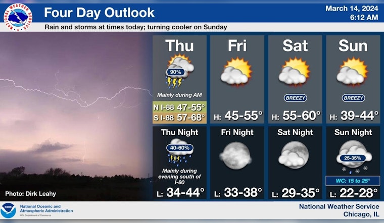
Chicago's forecast for today includes showers and thunderstorms rolling through before a slightly calmer evening sets in. According to the National Weather Service, residents should expect "showers and thunderstorms before 3 pm" with "new rainfall amounts between a quarter and half of an inch possible." The weather will marginally improve tonight with still a 50% chance of rain and gusts reaching up to 30 mph.
While the worst of the storms seems to be scheduled for the morning, the afternoon could still see some thunderous action as storms are to possibly redevelop. The Hazardous Weather Outlook warns of an "Elevated Thunderstorm Risk" along with a "Limited Tornado Risk mainly south of the Kankakee and Illinois River Valleys." These conditions are expected to gradually move south as the day extends into the evening.
By Friday, things are looking up with the skies clearing to mostly sunny and a high near 45 degrees, and breezy conditions will persist into the weekend. If you're planning to head out onto Lake Michigan, think twice, as the National Weather Service cautions about "Hazardous conditions for small craft" through Monday.
After today’s rain and storms exit the area, drier conditions are expected into this weekend. Cooler temperatures will also return to the area on Sunday. #ilwx #inwx pic.twitter.com/Gjacw1eDTB
— NWS Chicago (@NWSChicago) March 14, 2024
Looking ahead, Chicagoans can breathe a sigh of relief as calmer weather prevails after today's tumult. The National Weather Service Chicago posted, "after today’s rain and storms exit the area, drier conditions are expected into this weekend." But don't pack away all your warm gear just yet, as cooler temperatures are to quickly return on Sunday with highs around a brisk 41 degrees.


