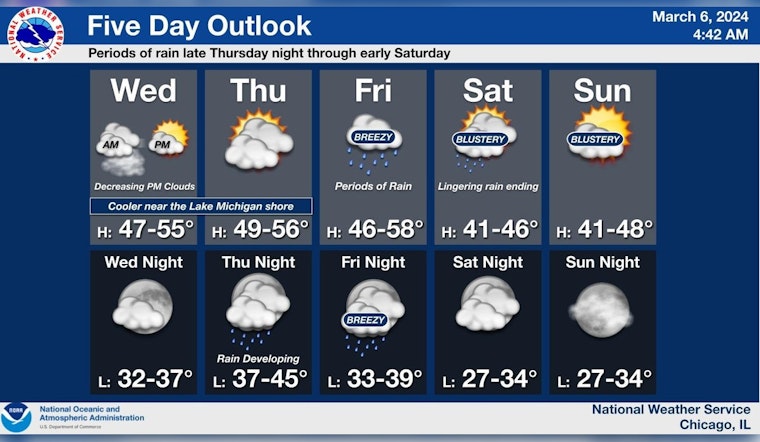
Chicagoans are looking at a varied bag of weather this week, according to the National Weather Service. Today’s forecast indicates patchy drizzle and areas of fog before 9 a.m., leading to eventual clearing with highs around 43 degrees. Brisk northeast winds might just add a chill in the air, with gusts reaching up to 25 mph. As night falls, temperatures are expected to dip only slightly, with lows settling around 38 degrees amid partly cloudy skies.
The gradual uptick in temperatures will continue through Thursday, promising partly sunny skies and highs near 44 degrees. But the NWS has flagged a rapid switch to wetter conditions by Friday, with rain set to dominate the scene "mainly after 7 am." An 80% chance of precipitation means it's likely time to break out the umbrellas and rain boots. A similar story unfolds into the night, with rain persisting before clearing towards Saturday morning.
After a cloudy and foggy start, cloud cover will decrease thru the PM. Seasonably mild weather expected today and Thu before our next weather system results in rain Fri into AM Sat. Cool and blustery weather for the weekend. #ILwx #INwx pic.twitter.com/Y05btfweBb
— NWS Chicago (@NWSChicago) March 6, 2024
While the Hazardous Weather Outlook indicates a break in the downpour come Saturday afternoon, the forecast isn't entirely dry. Chicago could see a 50 percent chance of more rain, mainly before 1 p.m., continuing the weekend's cool, "blustery weather." And any sailors out there should take note as gale force winds and very hazardous waves are "likely" come Saturday, possibly giving some serious grief to small craft on Lake Michigan.
The weather service is also cautioning about "limited flooding risk" from Friday to Saturday morning, hinting that some waterlogged areas could emerge. Sunday and Monday, however, present a silver lining with sunny conditions and temps climbing up to a cheery 54 degrees. Chicagoans can keep their fingers crossed for a streak of mostly sunny days into Tuesday with a high near 60, shaking off the last of the week's rainy blues.


