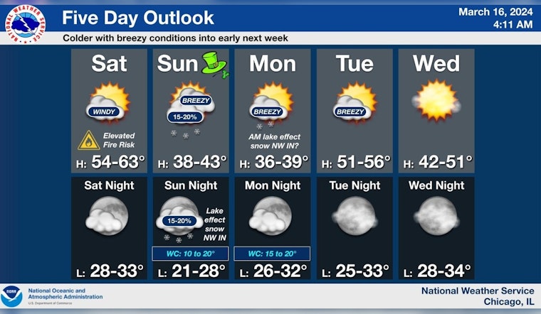
Chicago residents brace for powerful gusts and potential fire dangers as the National Weather Service (NWS) reports breezy conditions with southwest, shifting to westerly winds that could reach speeds of up to 40 mph. According to the detailed forecast for the Windy City, these robust winds, prevalent throughout today, are expected to challenge Chicagoans with an elevated risk of brush fires, especially given the dry conditions.
The Hazardous Weather Outlook from NWS Chicago/Romeoville IL underscores the potential for an "Elevated Fire Weather Risk" today, concurrent with "Limited Non-Thunderstorm Wind Risk." Despite the imminent risk posed by the strong winds, no spotter activation will be necessary for the day.
Windy conditions are expected today, with southwest to westerly gusts to 40 mph, resulting in an elevated fire spread risk. Breezy conditions continue into early next week amid colder temps, including a chance for a few snow showers on Sunday. #ILwx #INwx pic.twitter.com/SZAmtKNuwa
— NWS Chicago (@NWSChicago) March 16, 2024
Looking ahead, the treacherous conditions are anticipated to relent in the coming days with no hazardous weather in the forecast. However, Chicago isn't out of the woods yet. Colder temperatures are on the horizon, including "a chance of snow showers on Sunday," as reported by NWS Chicago. As the week progresses, Chicagoans can expect partly sunny days with highs sputtering just below the mid-40s, while nights may bring temperatures hovering around the freezing mark.
The capricious March continues to keep Chicago on its toes with the forecast indicating a mix of rain and snow showers by the week's end. And for those navigating Lake Michigan, the outlook isn't much calmer with the promise of "gale force winds and or very hazardous waves" posting challenges on the nearshore waters today. As reported by the National Weather Service, the windy affair will likely continue into early next week, suggesting boats and sailors prepare for "hazardous conditions for small craft," on Sunday through Tuesday and again on Friday.


