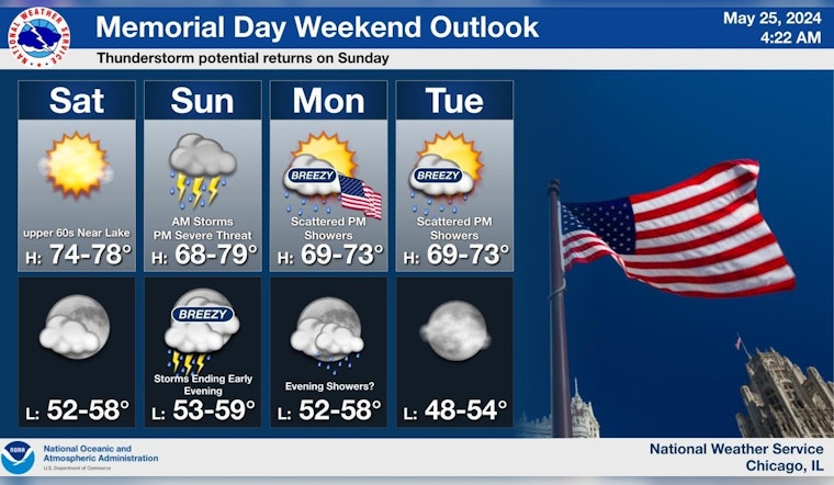
Chicago faces a stormy Sunday, with the National Weather Service issuing a warning for severe weather, including a high probability of thunderstorms, some potentially producing large hail, damaging winds, and isolated tornadoes, particularly south of Interstate 80. Chicagoans can expect two waves of storms; the first in the mid to late morning, and a more volatile second round in the afternoon and early evening, as detailed by the National Weather Service's Chicago office.
One or two rounds of storms expected Sun. The first is expected in the mid-late AM, with the second sometime during the mid to late PM. Second round of storms may be severe, especially south of I-80. Stay tuned! #ILwx #INwx pic.twitter.com/K95cevyCUt
— NWS Chicago (@NWSChicago) May 25, 2024
The mild and sunny disposition of today's weather, boasting a high near 68 degrees and a gentle eastward breeze, will be short-lived as transition rolls swiftly at nightfall, partly cloudy skies humbling into a low around 58 degrees, and winds remain tame, according to forecast.weather.gov. Sunday heralds instability; with showers and thunderstorms likely before 1 p.m., progressing into showers and a probable thunderstorm between 1 p.m. and 4 p.m., followed by an increased likelihood of thunderstorms after 4 p.m., the southeast wind gusting as high as 25 mph and new rainfall amounts ranging from a quarter to a half-inch.
The Hazardous Weather Outlook released by the National Weather Service outlines an elevated severe thunderstorm risk and limited flooding risk due to Sunday's conditions, with anticipation of "additional waves of thunderstorms" and the warning for severe storms "south of Interstate 80 across central parts of Illinois and Indiana." On Monday and Tuesday, the forecast suggests a more temperate scenario with scattered showers and isolated thunderstorms possibly flaring up in the mid-afternoon to early evening.
Looking ahead, Memorial Day offers a reprieve with a modest 20 percent chance of showers amidst mostly sunny skies and high temperatures near 72 degrees, with similar patterns stretching into next week, the forecast predicts a mix of some days sunny others the shadow of a slight chance of showers and thunderstorms that teases more than it threatens, especially in the evenings with nighttime skies largely clear and tranquil harboring lows in the mid-50s. Boaters on Lake Michigan should exercise caution as "hazardous conditions for small craft are likely" on Sunday, coupled with the "Elevated Thunderstorm Risk" during the same period, as stated by the National Weather Service's Hazardous Weather Outlook.
Residents and visitors in the City are advised to stay vigilant and regularly check updates, as local forecasts can rapidly evolve. Staying informed is crucial as the weather situation develops and potentially disrupts the many outdoor plans typical of a Chicago summer kickoff weekend.


