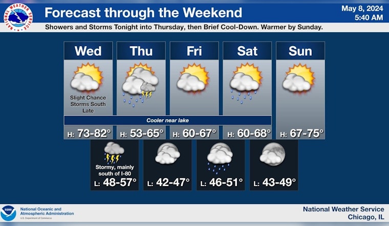
The Windy City is set for a meteorological rollercoaster this week, starting with a sunny high near 75 degrees today before a tumultuous turn to showers and thunderstorms later this evening. The unstable weather will continue into Thursday, bringing cloudy conditions and a steady temperature around 53 degrees, alongside gusty northeast winds that could see speeds reaching up to 30 mph; the chance of precipitation is pegged at a persistent 70 percent, with possible new rainfall totaling between a quarter and half of an inch, according to the National Weather Service.
Mostly sunny and warm today, then showers and thunderstorms return this evening into Thursday. A few strong to severe storms are possible south of I-80 this evening. Turning cooler Thursday, then gradually warming over the weekend. #ILwx #INwx pic.twitter.com/aaeHUClAgj
— NWS Chicago (@NWSChicago) May 8, 2024
Tonight Chicagoans should brace for potentially severe weather, as the outlook includes a "Limited Damaging Wind Risk" with speeds that could hit up to 60 mph and a "Limited Hail Risk" with hail up to quarter size, as per the NWS Hazardous Weather Outlook, conditions on Lake Michigan also warrant attention, as there's a "Limited Thunderstorm Wind Gust Risk" up to 50 knots threatening the Illinois and Indiana nearshore waters.
As we move through the weekend after Thursday's cooler air and bouts of precipitation, Chicago can look forward to a gradual warm-up, with mostly sunny skies slated for Friday and a high of 65 degrees, followed by chances of showers Friday night and a slight chance of showers and thunderstorms on Saturday, as detailed by the National Weather Service; come Sunday, residents can expect plenty of sunshine with highs nearing 69 degrees.
NWS Chicago cautions that a few strong to severe storms are possible this evening specifically south of Interstate 80 that might bring about heightened weather risks. The rest of the week is expected to mellow out somewhat with Saturday's 30 percent chance of precipitation giving way to clearer skies by nightfall, and Sunday offering up the promise of sunshine and milder conditions to round out the weekend.


