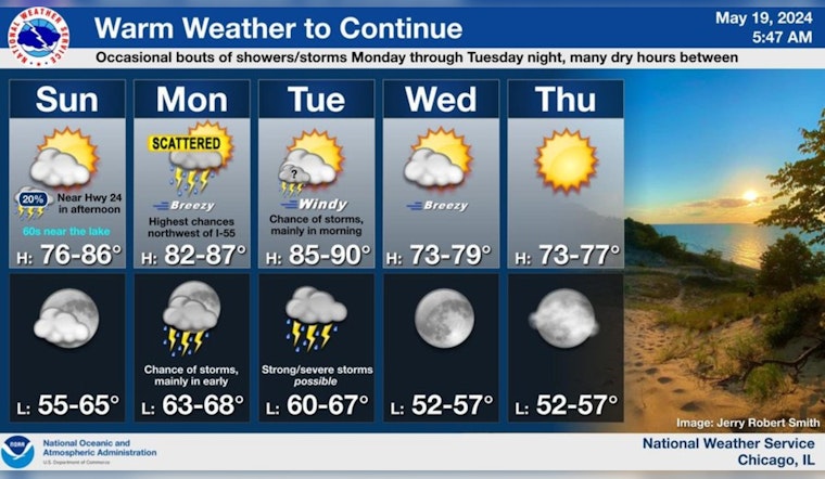
Chicagoans are in for a mixed bag of weather conditions this coming week, with sunny skies today giving way to possible thunderstorms and severe weather risks. Temperatures today will hit a comfortable high of 68 degrees, with the wind shifting from northwest to north-northeast and possibly gusting as high as 20 mph, according to National Weather Service. Come nightfall, locals can expect the mercury to dip to around 57 degrees.
As the new week rolls in, so does the potential for more tumultuous weather. The National Weather Service indicates a 50% chance of showers and thunderstorms after 1 pm on Monday, with highs soaring near 84, and south-southwest winds could reach speeds as high as 25 mph. Similarly, Tuesday will bring a 40% chance of storms before 1 pm, with conditions getting breezy, and winds potentially gusting to 30 mph.
An alert has been issued by the National Weather Service concerning possible severe weather early in the week. "Scattered thunderstorms are likely Monday, especially during the afternoon and early evening. Conditions will probably become marginally supportive of a couple of the storms briefly becoming severe, mainly between 2 PM and 8 PM," the agency's Hazardous Weather Outlook states. If conditions worsen, hail up to around 1 inch in diameter, and wind gusts up to around 60 mph could become a reality for the Windy City.
The week will carry on with mostly sunny skies predicted for Wednesday, with a pleasant high of 77 degrees. But come Friday night, the city could, once again, see a chance of showers. The weekend caps off with a continuation of possible showers and a high near 76 degrees on Saturday. Also on Tuesday evening and night, a significant storm risk with elevated severe potential is anticipated. "Some of these storms could become severe, with the highest chances of severe weather near and west of the Interstate 39 corridor," the outlook advises. Boaters should take heed, as hazardous conditions for small craft are likely on Tuesday and Tuesday night.
A lake breeze will provide for cooler weather near the lake today, but well inland highs will be in the 80s again. 80s return areawide Mon 🙴 Tue, w/highs possibly close to 90 on Tue! There’ll be some sct'd storms at times mainly Monday afternoon/evening, then again Tue night. pic.twitter.com/JSVrptTb3Q
— NWS Chicago (@NWSChicago) May 19, 2024
Adding to the forecast's nuance, a lake breeze is expected to cool things down by the water today, though areas further inland will experience temperatures in the 80s once more. According to a post from the National Weather Service Chicago, the region could see highs close to 90 on Tuesday. Despite the warm weather trend, area residents should remain vigilant and prepared for sporadic storms, especially Monday afternoon and evening, then again on Tuesday night.


