Dallas residents should brace themselves for a string of potentially severe weather conditions in the coming days. According to the National Weather Service in Fort Worth TX, a 20 percent chance of showers and thunderstorms is expected after 4 pm today, and some storms could turn severe. The forecast predicts a high near 92 degrees with heat index values soaring as high as 101. A south-southwest wind around 15 mph could kick up gusts of up to 25 mph, as per the National Weather Service.
Tonight, the chances of thunderstorms rise slightly to 30 percent, mainly occurring between 7 pm and 10 pm. Residents should not be fooled by the partly cloudy skies as storms may intensify to offer severe weather, while the temperature dips to a low around 69 degrees. As if to remind us of nature's unpredictability, the winds are set to shift from south to east-northeast after midnight. Despite the tumult, Thursday promises a 40 percent chance of more storms after 1 pm that could again be severe, with a high near 83 degrees. This pattern of storm risks is predicted to continue intermittently through Tuesday.
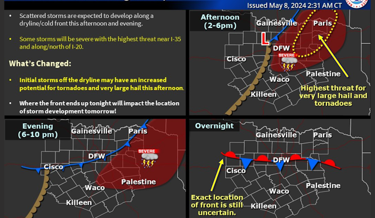
Adding to the Dallas-Fort Worth area's woes, the Hazardous Weather Outlook issued early this morning warns of possible severe thunderstorms today and tonight, particularly along and east of I-35, with large hail, damaging winds, and a chance of tornadoes. "Some storms may be severe with large to very hail and damaging winds. A tornado or two may also occur," the advisory states, highlighting the gravity of the expected conditions.
Beyond today, the risk for thunderstorms continues with Thursday afternoon and evening looking likely for another round of severe weather, mainly along and south of the I-20 corridor. The National Weather Service cautions that these storms could bring large hail, damaging winds, and potentially a tornado or two, with flooding a possible hazard in some areas. Residents are advised to remain vigilant as storm chances are to stubbornly persist on Sunday and continue through Tuesday. A sounding bell for preparedness, the Hazardous Weather Outlook mentions, "Limited spotter activation may be requested this afternoon and evening along and east of I-35."
In light of the impending weather threats, locals should stay informed and prepared for quick action. Monitoring updates from weather services seems crucial in the coming days as the storm system decides to make its journey through North and Central Texas. With preparations in place and a watchful eye on the sky, Dallas citizens can better navigate the instability that nature so often presents.


