Residents of Chicago are advised to prepare for a variety of weather conditions, beginning with scattered showers and possible thunderstorms throughout the area today. According to a forecast from the National Weather Service, the likelihood of precipitation stands at 60%, and while severe weather isn't predicted, there is still cause to remain alert and prepared for rapidly changing conditions.
The weather outlook intensifies with a "Limited Thunderstorm Risk" for the region, as noted in the latest hazardous weather report by the National Weather Service Chicago/Romeoville IL. The report specifically points toward high swim risks along Lake Michigan beaches starting Monday. Residents planning visits to the lakefront should take this into account and exercise added caution.
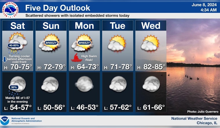
Following today's unsettled weather pattern, a significant shift will be felt as cooler air descends by the afternoon. The changeover will drop temperatures from the 70s into the 60s as articulated in a five-day outlook by NWS Chicago. By mid-week, this temporary cool-off will give way to a summery rebound with temperatures projected to soar into the 80s come Wednesday.
Scattered showers are expected today with a low chance (15%) for isolated embedded storms. A cold front will quickly drop temperatures from the 70s into the 60s during the afternoon. Cooler conditions continue early next week before 80s return on Wednesday. #ILwx #INwx pic.twitter.com/Y2rdP07qCZ
— NWS Chicago (@NWSChicago) June 8, 2024
Boaters are also being alerted to "Hazardous conditions for small craft" both today and over the next couple of days, a reminder that underscores the unpredictability and power of nature's elements when they converge upon a city so intimately linked with its waterfront. This caution extends to the Illinois and Indiana nearshore waters of Lake Michigan, where vigilance against the capricious waters during these days cannot be overstated.


