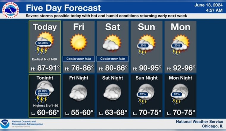
The city of Chicago is poised for a bout of severe weather, as the National Weather Service (NWS) Chicago/Romeoville has issued multiple advisories across north central Illinois, northeast Illinois, and northwest Indiana. Today, residents can expect "Showers and thunderstorms likely, mainly after 4 pm," with a chance these storms could produce heavy rainfall, as stated by the National Weather Service. Temperatures will hover near 89 degrees with southwest winds reaching 10 to 15 mph, with the possibility of gusts up to 25 mph.
A special weather statement has been issued for Elgin IL, Schaumburg IL and Hoffman Estates IL until 8:15 AM CDT pic.twitter.com/GpXMOClexQ
— NWS Chicago (@NWSChicago) June 13, 2024
With a 60% chance of precipitation tonight, thunderstorms are likely again before 1 am, potentially bringing heavy rainfall before skies clear to a low of around 65 degrees. These weather conditions have also prompted a Hazardous Weather Outlook, escalating the alert to a "Significant Thunderstorm Risk", which includes a potential for damaging wind and hail, and a tornado risk. According to the Hazardous Weather Outlook report, storms today could bring winds up to 75 mph and hail up to two inches in diameter. The Outlook mentions "Limited Flooding Risk" as well.
An isolated storm can’t be ruled out toward the WI/IL stateline early this morning, otherwise expect additional thunderstorms this afternoon and evening, some likely severe. After a slightly cooler end to the week, hot and humid conditions return early next week. #ILwx #INwx pic.twitter.com/sd8IBLN1HR
— NWS Chicago (@NWSChicago) June 13, 2024
Transitioning into the weekend, Friday offers a reprieve with sunny skies and a high near 73, while Saturday remains mostly sunny with temperatures reaching near 78 degrees. But the respite doesn't last, as "a 20 percent chance of showers and thunderstorms" is expected by Sunday, warns the NWS. The NWS advisory also notes a "Limited Heat Risk" from Sunday through Wednesday, underlining the dynamic shift in weather conditions over the coming days.
For those nestled along the shores, the marine forecast doesn't promise calm waters. "Elevated Thunderstorm Risk" with possible thunderstorm wind gusts up to 65 knots and large hail looms over the Illinois and Indiana nearshore waters of Lake Michigan. Furthermore, a special weather statement was issued this morning for Elgin IL, Schaumburg IL, and Hoffman Estates IL, signaling the breadth of the storm's impact. The effects of this storm system, as outlined by the NWS Chicago, are already being felt and could continue to affect the area until 8:15 AM CDT.


