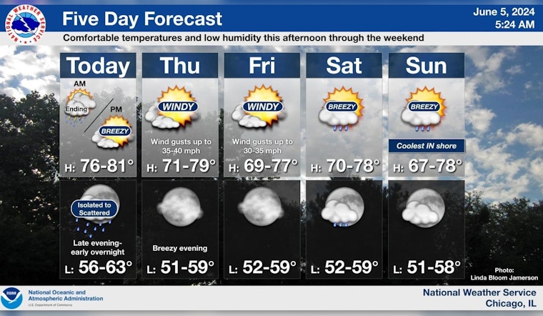
Chicago residents can anticipate a mix of weather conditions today, with showers and thunderstorms likely in the morning, followed by gradual clearing and highs approaching 80 degrees, as detailed in a report by the National Weather Service. West southwest winds are expected to reach 10 to 15 mph, with gusts potentially hitting 20 mph, and while the chance of precipitation stands at 60%, rainfall is forecast to remain below a tenth of an inch outside of stormy areas.
The outlook for tonight includes a 40% possibility of further showers and thunderstorms before 1 am, moving towards a partly cloudy environment with lows around 63 and west winds around 10 mph gusting up to 15 mph. The rest of the week seems to fare better with sunny skies and comfortingly mild temperatures ranging from the mid-70s to the high 60s, amid another report obtained from NWS Chicago's forecast, which mentions potentially windy conditions on Thursday and Friday with gusts approximating 40 mph and a forecast of comfortable temperatures and low humidity through the weekend, though with spotty showers possibly disrupting the calm over Saturday afternoon and Sunday.
AM showers, any t-storms S of I-80, will end as a cold front moves thru, followed by a nice aftn. Isol’d-sct’d showers late this eve-early overnight. Windy Thu-Fri, (~40 mph gusts Thu). Comfy temps and low humidity thru wknd. A few spotty showers psbl Sat PM and Sun. #ILwx #INwx pic.twitter.com/aWbpbGfMFD
— NWS Chicago (@NWSChicago) June 5, 2024
While today's thunderstorm risk is deemed limited, a cold front is predicted to move across the Chicago area, bringing isolated to scattered showers late this evening and early overnight, according to the Hazardous Weather Outlook from the National Weather Service Chicago/Romeoville IL. This front is expected to move from west to east through midday, primarily affecting regions southeast of a Peru to Chicago line.
For marine interests, the Illinois and Indiana nearshore waters of Lake Michigan may also see a limited thunderstorm risk today and tonight; however, no severe weather is expected for the period, and spotter activation will not be necessary through tonight for marine or land areas, thorough details of the marine conditions are available in the Hazardous Weather Outlook. Looking ahead, hazardous conditions for small craft are likely on Thursday and Friday, suggesting extra caution for those planning to navigate the waters of Lake Michigan during this time.


