Minneapolis residents can expect a break from potential downpours with only scattered showers anticipated between 1 pm and 5 pm today, promising a mostly cloudy day with highs teetering near a comfortable 77 degrees. As per the information provided by the National Weather Service, the chance of precipitation remains at a modest 30 percent with a light north wind breezing through at 5 to 10 mph.
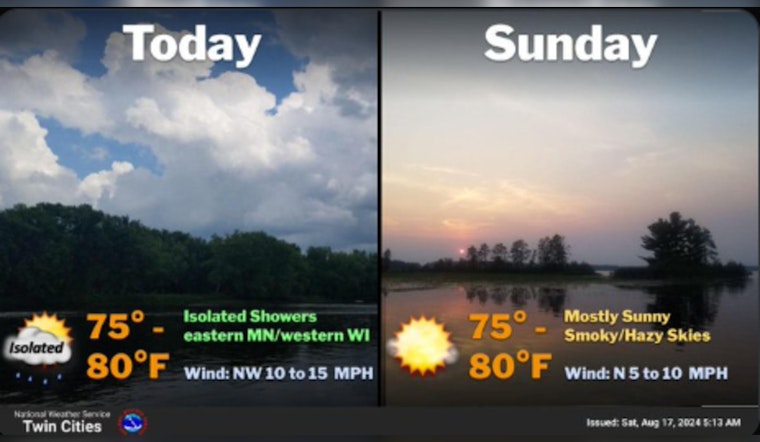
A few rain showers are possible again this afternoon, mainly across eastern Minnesota and western Wisconsin. We dry out Sunday and through much of next week, with lingering Canadian wildfire smoke leading to hazy skies.#mnwx #wiwx pic.twitter.com/1nAhBcOvWi
— NWS Twin Cities (@NWSTwinCities) August 17, 2024
For those planning evening activities, the sky partly clears up tonight with an isolated shower or two, possibly before 7 pm, but the real story is the patchy fog that's set to roll in after 3 am. While laying low around 63 degrees, the northeast winds will calm down as they whisper through the city, decreasing the chance of rain to an unlikely 10 percent, as the National Weather Service reports. Tranquil conditions are expected to continue into early Sunday, with areas of fog hanging around until 8 am.
Sunday appears sunny with the day's high near 82 degrees, providing a perfect setting for any outdoor plans. The north wind will be a silent partner, barely noticeable at 5 mph in the afternoon. A mostly clear Sunday night with lows around 62 degrees.
The workweek does kick off on a high note with an all-star sunny Monday and a repeat performance of Sunday's high of 82. While the northeast winds at 5 mph will try to steal the show in the afternoon, it will be anything but the center of attention. The nighttime ritual continues with mostly clear skies and a low whispering in at 62 degrees, as the east-northeast wind takes a bow, becoming calm.
The week's narrative unfolds with mostly sunny skies on Tuesday, as Mercury decides to float near 80 degrees, as detailed by the National Weather Service. The south-southeast breeze could spell a slight change, hovering around 5 mph. The plot twist sneaks in on Tuesday night with a tease of showers and thunderstorms after 1 am, though with only a 20 percent chance, most might miss the show. Cloud cover thickens, and temperatures are anticipated to stay steady with lows around 63 degrees.
Wednesday's forecast calls it mostly sunny with the high sticking close to 80 degrees, joined by a companionable south wind at 5 to 10 mph. The evening verges on partly cloudy as the mercury dips slightly to 64, maintaining the south-southeast wind's attendance at 5 to 10 mph. Closing out the week, Thursday serves up a familiar high of 82 and keeps hold of those south winds at 5 to 10 mph, but with a 20 percent chance of evening showers and thunderstorms.
The persistent Minneapolis melody plays on, with Friday expected to bask in mostly sunny skies once more, as the temperature high steps to around 82 degrees, dancing in with the consistent south wind at 5 to 10 mph, according to the National Weather Service.


