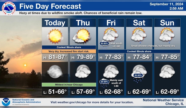
Chicago residents can look forward to a continued streak of mostly sunny days and moderate breeze this week, according to the National Weather Service. The detailed forecast for Chicago, IL predicts sunshine with temperatures in the mid-80s today and a slight shift from south to east-southeast winds in the afternoon.
Tonight, expectations of partly cloudy skies and mild southeastern winds will temper the evening to a low around 66, while Thursday promises more sun and slightly cooler high of 83. The outlook remains generally unthreatening; as the Hazardous Weather Outlook states, "No hazardous weather is expected at this time." This report covers both the northcentral and northeast of Illinois, as well as northwest Indiana.
Heading towards the weekend, the forecast from the National Weather Service suggests the weather will shift to mostly cloudy with highs teetering around 80 degrees. Each night is expected to settle into the upper 60s. Despite this pattern of cloud cover, the chance for showers notably resides in the 20 percent bracket for Saturday afternoon, crawling into the predawn hours of the following days.
Warm and dry conditions continue through today and Thursday with hazy skies at times due to wildfire smoke aloft. While low chances for showers exist Friday through the weekend, the potential for beneficial rainfall remains low. #ILwx #INwx pic.twitter.com/hvh7eK36YT
— NWS Chicago (@NWSChicago) September 11, 2024
Furthermore, while the skies may be overcast, the potential for any substantive rainfall remains elusive. Viewers may notice a hazy skyline on occasion as a result of wildfire smoke caught in the atmospheric layers aloft, as pointed out in a report by the National Weather Service Chicago. "Warm and dry conditions continue through today and Thursday with hazy skies at times due to wildfire smoke aloft." Despite these variations, the comfort of predictability blankets the region; no significant meteorological disruptions look to unsettle the rhythm of Chicago's mid-September tempo.


