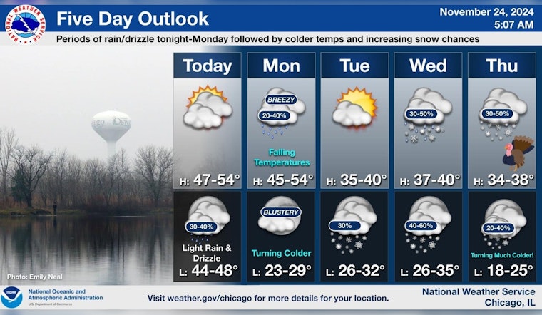
Chicagoans waking up this morning found themselves shrouded in patchy fog, which was expected to lift by 9 am. The forecast, obtained from the National Weather Service, also predicts a partly sunny day with highs expected to touch near 51 degrees. Winds from the southsoutheast are anticipated to blow at 5 to 10 mph, with possible gusts reaching as high as 15 mph.
Tonight, the city should prepare to experience patchy drizzle before 8 pm, followed by a mix of isolated showers between 8 pm and 10 pm, then transitioning to scattered showers after 10 pm. Cloud cover will persist, alongside a mild low of around 48 degrees. Looking forward, Monday will likely begin with similar patchy drizzle and isolated showers before giving way to scattered showers post-noon. During this time, Chicagoans can expect to briefly feel temperatures rise to near 50 by 9 am before they commence to gradually fall to about 45 throughout the remainder of the day. The temperature roller coaster accompanies winds shifting from the south to west-northwest at 10 to 15 mph by afternoon, and gusts might hit as hard as 25 mph, with a chance of precipitation holding steady at 40 percent.
Meanwhile, a report by FOX 32 Chicago highlighted a warm spell for Sunday with mostly cloudy skies and a high of 52 degrees, slightly above the seasonal average. However, a cooldown is expected to assert itself by midweek. Wednesday and Thursday are predicted to see a sharp decline in temperatures, struggling to peak in the upper 30s and low 40s, as a weather system begins to make its mark on the city.
The rest of the week leading up to Thanksgiving Day poses a chilly outlook for Chicago, as the National Weather Service predicts a chance of snow on the holiday. In the days preceding, Tuesday night presents a 20 percent chance of snow after midnight, and Wednesday night continues the trend with more possible snowfall. Both days are slated to see a high near 39 degrees and lows hovering around the mid-30s. In an offering of respite, Tuesday will be sunny, yet brisk with a high near 39, and winds traveling west at 10 to 15 mph with gusts that could reach to aggressively push 20 mph.
This wintery mix taps the brakes on any warm reprieve, as Friday and Saturday descend into colder climes with highs only reaching the low 30s and dipping into the chilling low 18 degrees at night. With this forecast, Chicagoans are reminded to dress warmly and prepare for the onset of early winter weather conditions that could disrupt travel plans and holiday activities.


