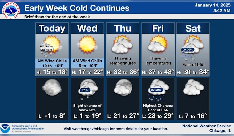
Chicago City braces for another rapid shift in weather patterns, where the streets will feel the snow before the sun graces the sky with its presence again. According to the National Weather Service, today's forecast anticipates snow, prevailing before 9:00 a.m., with an anticipated total daytime accumulation of less than one inch. As the snow subsides, Chicagoans can expect a mostly clear evening, with temperatures plunging to a low of around 5 degrees. Blustery conditions persist, with wind chills potentially reaching as low as -6.
Come Wednesday, the forecast suggests a sunnier disposition with a high near 21 degrees. However, the warm-up isn't set to stay, as Wednesday night hints at a 20 percent chance of snow after midnight. According to a report by FOX 32 Chicago, Thursday will initiate a warming trend, leading up to a near 40-degree high by Friday. Despite the thaw, the city will navigate a mixed bag of precipitation with the possibility of rain coming Friday night.
FOX 32 Chicago's weather forecast warns commuters to anticipate slick road conditions early Tuesday morning due to overnight snow accumulations. The wind chills will make it feel as cold as -10 degrees overnight. Slightly clearing in the afternoon, the city can expect partly cloudy skies with negligible comfort from the harsh cold.
Steering toward the weekend, the temperature swings back with highs tapering off to the lower 30s on Saturday. Per FOX 32 Chicago, a small chance of rain or snow showers is predicted. Onwards to Sunday, highs are anticipated to be in the teens, with the chill intensifying into a biting cold for Martin Luther King Day, with a forecast high hovering around 10 degrees.


