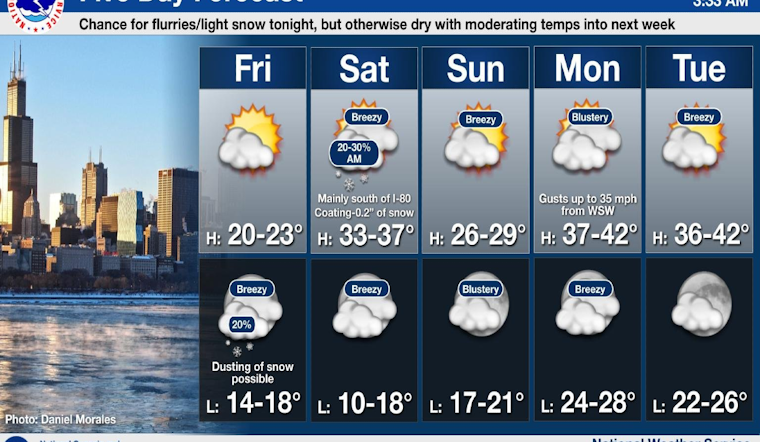
Residents in Chicago can expect a gradual rise in temperatures following a cold snap, with forecasts predicting intermittent flurries leading into a more clement week. According to the National Weather Service, today's weather sees increasing clouds with a chilling high near 21 degrees, and wind chill values dropping down to -6, while gusts could reach up to 20 mph.
"Intermittent flurries with a slight chance of snow after midnight" are expected, with mostly cloudy conditions envisioned and temperatures set to rise to around 21 by 3:00 a.m., according to NWS forecast. This comes in anticipation of a warmer Saturday when the mercury may soar to a high near 35 accompanied by intermittent flurries early in the morning but followed by mostly sunny skies. West southwest winds will continue at 10 to 15 mph, potentially gusting as high as 25 mph, and Saturday night's forecast anticipates partly cloudy skies with a low around 17 degrees.
FOX 32 Chicago confirms the warming trend, noting "Chicago will be cold again today with highs in the low 20s," yet the city will witness a "gradual warm-up" with Sunday expected to be slightly cooler presenting highs in the upper 20s under sunny skies. Beginning a week that will see mostly sunny conditions with temperatures ascending to the upper 30s through to 40 degrees by Monday and Tuesday.
Throughout the upcoming week, weather patterns appear stable, and remain in favor of those weary of winter's sting, Monday night will be "Mostly cloudy, with a low around 28 and breezy," according to NWS forecast. While later days maintain a mostly sunny disposition, though Wednesday night may deliver only partly cloudy skies with a low around 21. The sunshine persists through Thursday, with another mostly sunny day, although the high approaches a modest 31 degrees according to the forecasts.


