The skies over Knoxville remained heavy with clouds as temperatures hovered around a biting 28°F early this Tuesday morning, according to the National Weather Service (NWS) in Knoxville. With humidity at a substantial 80% and winds variable at 5 mph, the chill in the air felt sharper, driving wind chill values down to 22°F. A detailed forecast from the NWS predicts that the day will see partly sunny conditions, with the mercury struggling to reach a high near 34°F, offering a slight reprieve from the early morning's cold embrace.
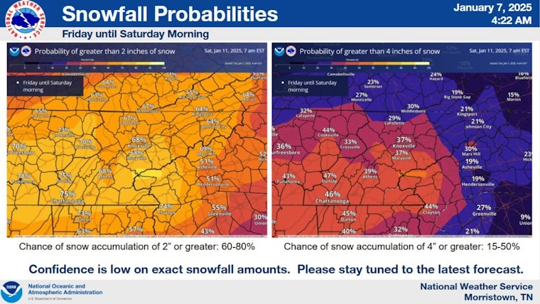
Impactful snow accumulation is possible Friday & Saturday. Details of how this system will develop and where it will track are uncertain, which will affect our snow amounts. The image shows the chance of seeing >2" and >4". This will change so stay tuned to the latest forecasts. pic.twitter.com/EleYXAsC5e
— NWS Morristown (@NWSMorristown) January 7, 2025
As night falls, the clouds are expected to clear partially, leading to partly cloudy skies with temperatures dipping to around 19°F. Light north winds will ease as the night progresses. Looking ahead to Wednesday, residents can expect mostly sunny conditions, with temperatures reaching a high near 35°F, as per the National Weather Service. The remainder of the week will feature fluctuating skies. Thursday brings sunshine, but Friday is set for a snowy turn, with a 60% chance of precipitation by evening, escalating to a 90% chance of snowfall overnight.
Some scattered snow showers continue this morning in parts of northeast TN and southwest VA. Slippery conditions are possible on untreated roadways. Moisture on roads may also freeze to form black ice. Use caution when traveling this morning. pic.twitter.com/9L1JzkyS3B
— NWS Morristown (@NWSMorristown) January 7, 2025
The NWS has issued a Hazardous Weather Outlook for East Tennessee, southwest North Carolina, and southwest Virginia regions. "Post-frontal snow showers continue for parts of the area through early this morning," the NWS Hazardous Weather Outlook statement lead, adding that in the mountains and some parts of southwest Virginia, one might witness a winter tableau painted with 1 to 3 inches of accumulated snow by sunrise. A Winter Weather Advisory remains in effect until the morning wanes, while the valleys and foothills may see a lighter, yet possibly treacherous dusting to a half-inch of snow, the changeover from rain to snow on Monday has left open the potential for the often-invisible hazard of black ice forming on roads and pavements, so the NWS encourages "extra caution driving or walking outdoors."
Looking ahead, uncertainty clouds the predictions for Friday into Saturday, as the region may be on the threshold of an "impactful winter storm," one that could bring significant snowfall. The NWS Hazardous Weather Outlook advises the public that, while "there is the potential for an impactful winter storm to produce accumulating snowfall." Therefore, the exact mix of precipitation and the amount of accumulation remains under the shadow of uncertainty as residents are encouraged to stay vigilant of future forecasts.


