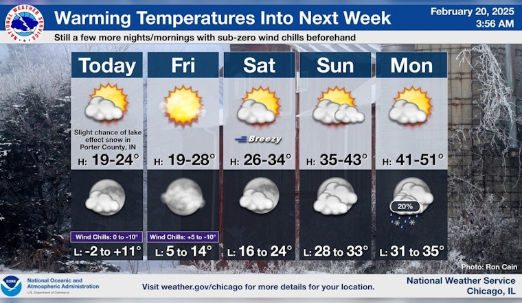
As Chicago braces for another biting day, the weather forecast promises only a slight reprieve from the cold front that has held the city in its grip. According to the National Weather Service, today's partly sunny skies will not suffice to raise temperatures significantly, with a high near 24 degrees and wind chill values skirting as low as -9. The northwest wind, ranging from 10 to 15 mph and gusting up to 20 mph, ensures that the chill remains a persistent presence.
Tonight, the NWS anticipates a low hovering around 10 degrees, with wind chill values again, threatening to dip to zero. Even as the wind slows to a west-northwest drift of 5 to 10 mph, gusts might still reach 15 mph. The forecast points to a gradual warming trend kicking in on Friday, with sunny skies and a high near 26 degrees, although wind chills could still fall to -1.
Looking ahead to the weekend, Chicagoans can expect a welcome thaw. Saturday's forecast from the NWS calls for sunny conditions with a high near 31 degrees, and a continued gentle southwestern wind of 10 to 15 mph. By Sunday, the mercury is set to graze a more comfortable high of 38 degrees under partly sunny skies.
Moreover, CBS Chicago reports that after another frigid night with sub-zero wind chills on Thursday, the city will see temperatures reaching freezing for the first time in nearly six days by the weekend. "Several warmer than normal days are expected next week, in the 40s from Monday through Wednesday," notes the report, signaling an impending respite from the relentless chill that has been the hallmark of past days.


