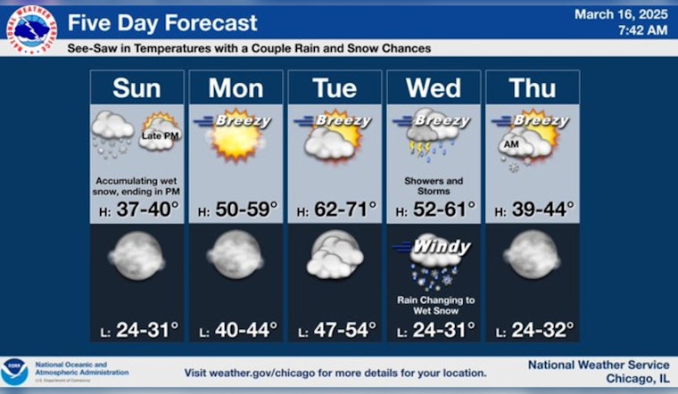
Chicagoans are advised to brace themselves for a slight hint of winter before a promising warm-up as they head into the new week. According to a recent forecast from the National Weather Service, snow is expected today, primarily before 3pm, with less than a half inch of accumulation. Temperatures are forecasted to hover near 38 degrees, with northwest winds at around 15 mph and gusts that may reach 20 mph. Tonight, residents can expect mostly clear skies with a low around 30 degrees and lighter west-northwestern winds.
The coming days, however, will bring a definitive shift to warmer weather. Although tonight is set to be cold, Monday promises a substantial rise in temperatures. Tomorrow's weather is slated to be mostly sunny, with highs around 53 degrees. The south wind is also predicted to pick up to a breezy 15 to 20 mph, potentially gusting as high as 30 mph.
Following in tune with this warming trend, Tuesday and Wednesday are looking particularly bright, with forecasted highs climbing into the 60s. But Wednesday holds the potential for showers and possibly a thunderstorm as "a 20 percent chance of showers after 1am" increases to a 90 percent chance of precipitation during the day, as indicated by the National Weather Service.
This warmth and wetness will dramatically switch back to wintry conditions by Wednesday night, including rain and snow before 1am, with temperatures taking a sharp dip to around 30 degrees. The remainder of the week is expected to gradually warm up again, culminating in a high near 53 degrees by Saturday.


