Knoxville is bracing for a mix of weather conditions in the coming days, from sunny skies to potential showers. According to the National Weather Service, today's forecast predicts sunny weather with temperatures climbing to a comfortable high near 70°F. The calm is expected to give way to a light southwest wind in the afternoon. Stepping into tonight, the weather is slated to stay partly cloudy, with lows dipping to around 44°F.
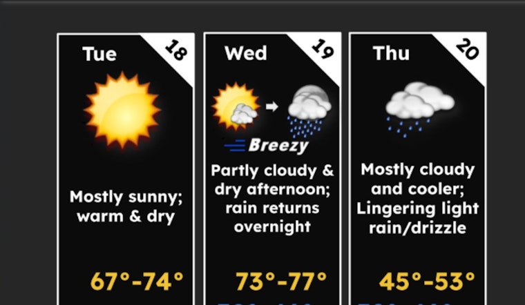
Today and Wednesday afternoon will be very dry. Breezy winds will accompany the dry air Wed afternoon. A cold front brings increasing rain chances Wednesday night (60-90%). Cooler temperatures with some lingering light rain/drizzle (25-50%) expected behind the front Thursday. pic.twitter.com/WLolZvPbYD
— NWS Morristown (@NWSMorristown) March 18, 2025
Wednesday elevates the weather ante with temperatures reaching an even warmer high near 76°F. However, be prepared for winds picking up to 10 to 15 mph, alongside gusts that could reach up to 30 mph. As we creep into Wednesday night, showers are on the horizon, predicted to start mainly after 2 am. The chance of precipitation is pegged at 90%, with wind speeds continuing around 10 to 15 mph, and gusts as high as 25 mph, as detailed by the National Weather Service. Falling temperatures overnight will settle at a low of around 44°F.
The rainy reprieve is short-lived with showers anticipated to continue mainly before 8 am on Thursday. The day's temperatures will take a plunge to an expected high near 52°F. The gusty southwest wind persists, reaching speeds of up to 25 mph. The National Weather Service cautions that these conditions bring an 80% chance of precipitation. Thursday night's forecast looks clear in comparison, partly cloudy with a low around 32°F and winds simmering down to 5 to 10 mph, with gusts potentially hitting 20 mph.
The end of the week ushers in a return to sunnier days with Friday's high expected to leap near 60°F, under calm winds which will eventually adopt a subtle westerly direction at around 5 mph. However, the calm is not meant to last with Friday night potentially bringing a "20 percent chance of showers after 2am," as per the NWS. Temperatures will again drop overnight to a low of around 41°F.
Saturday is mostly ensconced in sunshine with a lingering 20 percent chance of showers before 2pm and highs expected around 65°F. The night maintains a trend of clarity with mostly clear skies and lows hovering around 39°F. By Sunday, a 20 percent chance of showers creeps back into the forecast, though mostly sunny conditions prevail, with a high near 71°F.
As stated by the Hazardous Weather Outlook report issued by the National Weather Service in Morristown TN, "Low relative humidity this afternoon may pose a heightened wildfire risk." In fact, for East Tennessee, "Low relative humidity and gusty winds may pose a heightened wildfire risk Wednesday afternoon." East Tennesseans in the mountains and foothills should take particular note of "gusty winds between 40 to 55 mph" expected Wednesday night. The report emphasizes that "spotter activation is not needed at this time."


