Chicagoans have been bracing themselves through a series of cool days, with the weather forecast suggesting modest temperatures and sporadic showers might persist. According to a report by the National Weather Service (NWS), cited by NBC Chicago, the city has been wrapped in a nearly unyielding embrace of cool air, thanks to an unusually long period of onshore flow resulting from a persistent high-pressure system over the northern Great Lakes. This has led to an extended stretch of days with high temperatures ducking under the 60-degree mark.
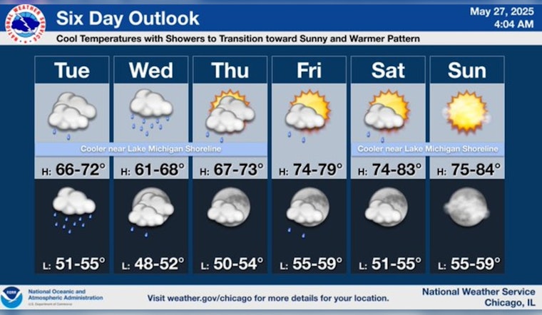
This cold spell is making itself felt across the city, as the forecast from the National Weather Service predicts a possibility of showers and a high of merely 62 degrees today. The night extends the cool temperatures with an expected low of around 53. Wednesday ramps up the chance of rain to 50 percent, continuing the trend of cool, wet weather. A similar pattern of cool nights and chances of rain persists through to Thursday night, with a slight warm-up anticipated by the weekend.
The outlook, however, shifts as the weekend approaches. "Temperatures will be warming up each and every day this week," says NBC 5 Storm Team Meteorologist Alicia Roman. By Friday, Chicagoans can anticipate a sunnier day with a high near 79 degrees. The warming trend promises a heftier break in the clouds and a rise in temperatures through the weekend, hinting at the awaited shift in weather patterns that Chicago is eager to embrace.
The fleeting nature of this week's rain, mostly scattered, signals the approach of what is expected to be a more sizable shift in weather patterns by early next month, as reported by the NWS. More immediately, the NBC 5 Storm Team anticipates this shift to begin at the tail end of the week, projecting weekend temperatures that leap into the mid-80s for most residents in the region. Until then, locals can expect to face another gray curtain of clouds and a potential wave of heavier rain on Wednesday, painting another cool, wet path through midweek.


