Chicago residents faced a deluge from the skies early Thursday morning, with widespread showers and thunderstorms drenching the northeast parts of Illinois. NBC Chicago reported heavy downpours across several counties, stirring up trouble for morning commutes as roadways turned treacherous.
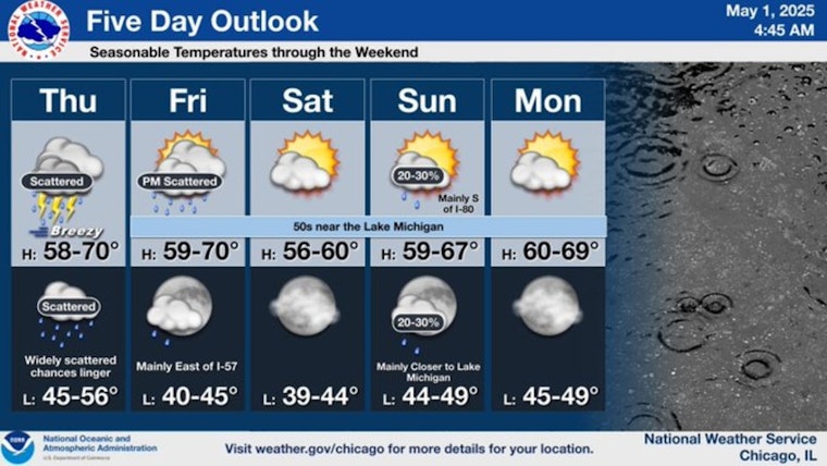
Periods of showers and a few thunderstorms are expected today, though there will be dry periods. Drier conditions are expected through most of the weekend with highs in the 60s and low 70s. #ILwx #INwx pic.twitter.com/DirmSuG1RF
— NWS Chicago (@NWSChicago) May 1, 2025
Emerging before dawn, Live Doppler 5 radar captured the intense rainfall enveloping regional areas such as DeKalb and McHenry. Traffic crashes and ramp mishaps were spotted by traffic reporter Kye Martin, as rain slicked the streets, indicating that the weather was having a tangible impact on the everyday hustle, as per NBC Chicago. An upwardly lifting band of rain is expected to continue pressing into central Cook County into the late morning, promising a soppy extension to what's already been a wet start to the day.
Despite the tumult of the morning, this watery siege isn't forecasted to let up soon. The National Weather Service predicts a high chance of showers and thunderstorms extending beyond morning hours, with a high likelihood of precipitation through the afternoon. The wind, possibly gusting up to 30 mph, is not expected to cut any slack for those navigating the wet and breezy conditions of the Windy City.
Temperatures, hovering near the 60s, are a bit cooler than the seasonal norm, indicating a slight reprieve from what might have been a more stifling scenario. But comfort brings little solace to those looking skyward, apprehensively eyeing the next wave of showers. "Still keeping rain chances pretty much at every time, but not everyone will see it," Alicia Roman of NBC's Storm Team said, as stated by NBC Chicago.
As Friday approaches, expectations of a drier interlude are tempered by the likelihood of evening rains, particularly in the northern and western fringes, where another wet front is forecasted to make its presence known. The subsequent days bring a cooler palate, with Saturday projected to feature partly sunny skies but temperatures remaining in a modest range of 50s and 60s.


