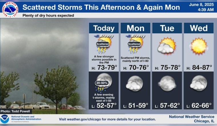
The weather in Chicago is set for a series of changes over the next week, with fluctuating conditions that residents should be prepared for. According to the National Weather Service, scattered showers and thunderstorms are anticipated later today, with increasing clouds and a high near 79. As evening approaches, there's a likelier chance of showers and thunderstorms, particularly before 10 pm, followed by isolated showers tapering off near 11 pm.
Heading into the new week, Monday has a 50 percent chance of storms cropping up after 1 pm, despite mostly sunny skies and a high around 75. By Wednesday, the skies will be clear, shining upon a high near 86 degrees, providing a brief respite before Thursday's chance of showers and thunderstorms in the afternoon. CBS News Chicago corroborates this, adding that heavy rain could affect certain parts of the region, particularly on Saturday night. These downpours might be notably impactful along and south of Interstate 88, hitting the southern suburbs and bits of northwest Indiana the hardest.
The variability of the weather extends into Sunday as well, with CBS News Chicago reporting that the morning may begin on a dry note, but be punctuated by gusty storms later in the afternoon due to an approaching cold front. Despite the tumult of the skies, the city's air quality is expected to hover in the moderate range, likely in part due to the dispersal of smoke from Canadian wildfires.
Weather forecasts predict the fluctuating pattern will stick around, with Tuesday and Wednesday bathed in sun and warmth, but Thursday through Friday renewing chances for afternoon showers and storms, signaling no respite for those weary of the rain. Looking ahead, it seems showers will continue to be a theme into next Saturday as well, with a high near 77 and chances of more precipitation.


