Chicago residents woke up to cooler temperatures and a haze that lingered into Sunday morning. According to Fox 32 Chicago, the city started the day with readings in the upper 30s and 40s, hinting at the beginning of a significant warm-up. While lakefront areas held steady in the 50s, southwestern suburbs edged closer to the 70s.
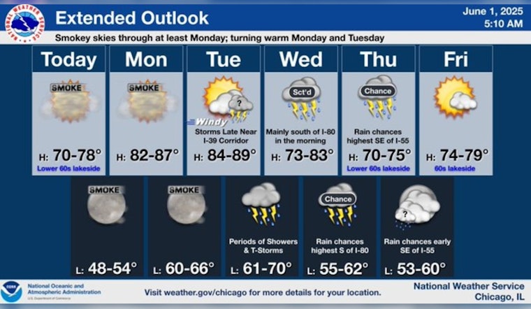
Fox 32 Chicago's meteorologist, Mark Strehl, forecasted that the hazy conditions might see some improvement later in the day, only to return by Monday. Despite the smoky skies, a high-pressure system is expected to keep the weather dry throughout Sunday. However, as the week kicks off, so do the temperatures, expected to soar into the upper 80s and potentially the 90s.
The National Weather Service confirms the upswing, predicting a sunny Monday with a high near 86 degrees and gusts hitting as high as 20 mph. Heading into Tuesday, the city should brace for breezier conditions, as wind speeds increase and bring along a chance for showers and thunderstorms in the afternoon.
As for the remainder of the week, the likelihood of precipitation escalates by Wednesday, with an 80% chance of showers and possible thunderstorms. These patterns are slated to continue, with Thursday also showing potential for storms, chiefly in the afternoon, and the week concluding under sunnier skies by Friday.
Chicagoans can anticipate a mix of cloud cover and sun toward the weekend, with Saturday showing partly sunny skies and highs hovering around 69 degrees. While the weather presents an undulating pattern of calm and storm, residents should keep an eye on updates to stay informed and prepared.


