As Chicago residents took cover from the Sunday storms, which brought strong winds and hail through the area, the upcoming weather forecast suggests a mix of conditions for the week. Severe weather hit parts of Chicagoland, including a powerful storm that unleashed 70 mph wind gusts and ping pong ball-sized hail in Batavia in Kane County, as reported by FOX 32 Chicago.
A cold front that has been traveling through the region is expected to clear up the skies behind it, with temperatures projected to drop into the mid-50s tonight. While Monday is anticipated to be generally pleasant, with the chances of it being interrupted by a few showers and storms, severe weather is not on the radar according to the latest update from the National Weather Service at Weather.gov. High temperatures are expected to be in the lower 70s.
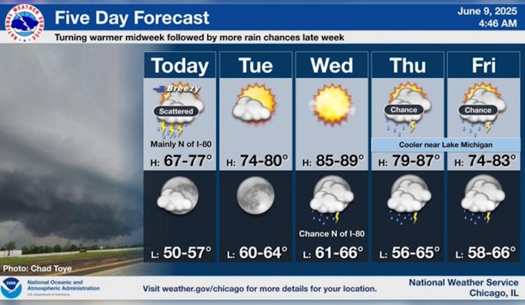
Looking ahead, Tuesday and Wednesday offer a respite from the unsettled conditions, with mostly sunny to partly cloudy skies and warm temperatures slated for both days—Tuesday is projected to see a high near 78, while Wednesday could see temperatures soaring into the high 80s. This mild reprieve is detailed in the forecast by the National Weather Service.
Returning to more variable weather, scattered showers and thunderstorms are foreseen later in the week. As the forecast suggests, Thursday through Saturday, commuters should prepare for storms that might bring the potential for heavy rain and gusty winds. While temperature highs on Thursday are expected, being in the mid-80s, they are forecasted to fall to the mid to upper 70s by the weekend—a fluctuation emphasized by FOX 32 Chicago.
Residents looking forward to outdoor activities or planning their commutes will, therefore, want to keep an eye on the latest weather updates.


