Chicagoans can expect a mix of conditions today with thunderstorms likely, especially after 5 p.m., and partly sunny skies beforehand. Highs are projected to hit near 86 degrees, according to a forecast from the National Weather Service. The south southeast wind could reach up to 15 mph, with potential gusts as high as 20 mph, making for a breezy day. "Showers and thunderstorms likely, mainly before 9pm," notes the National Weather Service.
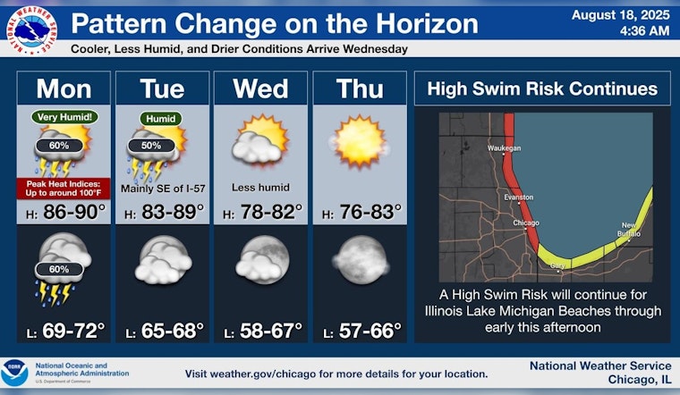
A shift is on the horizon for Chicago's weather as we inch towards the close of meteorological summer. FOX 32 Chicago reports that a change in humidity is expected by midweek. Prior to that, warm and muggy conditions will prevail. "Additional showers and thunderstorms will be possible at almost any time today and that may hold high temperatures in the upper 80s," stated FOX 32 Chicago.
The chance of precipitation drops to 30 percent on Tuesday, primarily before 10 a.m. Afterwards, the city will see partly sunny skies with high temps hovering again around 86. However, a shift in wind from southwest to north is expected by Tuesday afternoon. As the week progresses, the likelihood of rain decreases, paving the way for drier conditions and quieter skies.
Towards Wednesday, residents can anticipate partly sunny conditions with a high near 76 degrees, a welcome cooldown from humid highs. "The rest of the work week looks dry and quiet with highs ranging from around 80 on Wednesday and Thursday to 85 on Friday," detailed FOX 32 Chicago. The upcoming weekend is forecasted to remain sunny with highs in the low to mid-80s, offering Chicago a taste of idyllic summer weather as the season winds down.


