Chicago was hit by powerful storms and heavy rains overnight, which are now passing out of the area as of early Sunday morning, leaving behind a significant risk of flooding. According to the National Weather Service, the south and far western suburbs continued to experience the tail-end of the disturbances around 7 a.m., with a Flash Flood Warning in effect for parts of Will, Kendall, Grundy, and Kankakee counties until approximately noon.
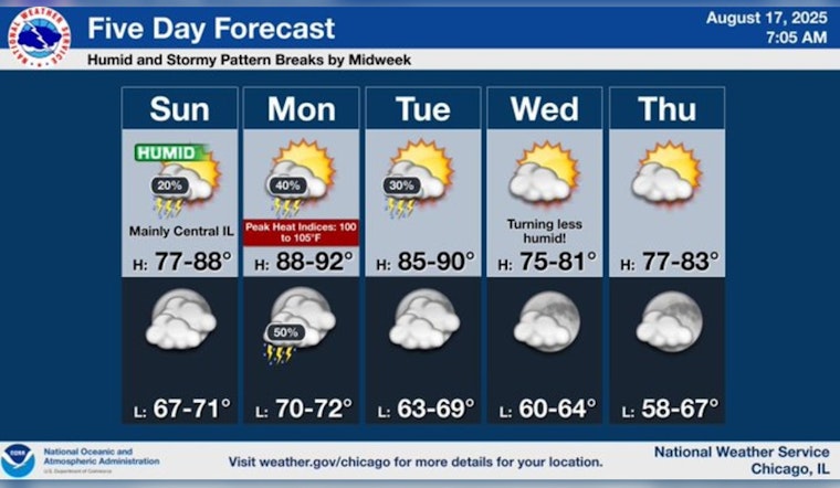
Fox 32 Meteorologist Mark Strehl's forecast mentioned on Fox 32 Chicago, indicates a heat advisory in place until 8 p.m with temperatures expected to soar to high 80s and potentially hitting 90 degrees in the western suburbs the storms had also caused widespread power outages affecting both the Chicago area and Northwest Indiana throughout the region.
As for power disruptions, roughly 69,000 residents in northern Illinois are coping with electricity loss as reported by ComEd, while NIPSCO listed about 8,100 customers in Indiana primarily in the northwestern region facing similar challenges after the overnight storms, making it a dark morning for many.
The conditions of Lake Michigan should give any beachgoers pause, with fast-building waves forecasted for Sunday afternoon through Monday morning with a Beach Hazards Statement put in place from 1 p.m. today through tomorrow morning the National Weather Service has broadcasted a warning of potentially life-threatening currents along all southern Lake Michigan beaches, warning "Stay dry when waves are high".
Despite the disruptive weather, things are looking up as the skies clear up moving into the week, with the National Weather Service anticipating a steady temperature with occasional showers and some sun, providing a mix of weather patterns for the Windy City. Residents are reminded to stay aware of local weather alerts as the city moves forward from the stormy conditions.


