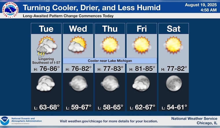
Chicago residents can anticipate a shift in weather patterns following recent flood advisories. According to FOX 32 Chicago, areas between I-88 and I-80 are still grappling with flood advisories and warnings, set to expire by midmorning today. Despite high humidity levels and mostly cloudy skies, temperatures are expected to hover near the 80-degree mark, with rain unlikely to add significantly to the already varied rainfall totals.
As commuters faced floods this morning traveling between highways I-88 and I-80, mild weather is on the horizon. Transitioning from recent storms that have left their mark, the National Weather Service forecasts reveal a trend towards a cooler late-summer spell, with chances of sprinkles dissipating early Wednesday and ushering in clear skies. The preliminaries of this welcome change will feature mostly sunny conditions, with temperatures expected to peak near 76 degrees, accompanied by north northeast winds.
Tonight's weather remains consistent, holding mostly cloudy and with lows not straying far from 70 degrees. "Today will be a close call for continuing that streak," reports FOX 32 Chicago, referencing the city's 13 consecutive days of above-average warmth, as residents might drape blankets additional, unneeded across their beds in preparation for a balmy evening.
The pattern change hinted by meteorologists brings more than just clear skies. By Friday, Chicagoans will witness highs climbing to the mid-80s, succeeding a sunny Thursday with high temperatures lingering in the low 80s. Then by Sunday, as people likely enjoy outdoor activities, they will experience highs in the admittedly cooler 70s, ensuring a respite from the heat. This signifies a refreshing start to the week, with National Weather Service predicting a sunny Monday toppling just past 70 degrees, promoting a gentle nudge towards autumn.


