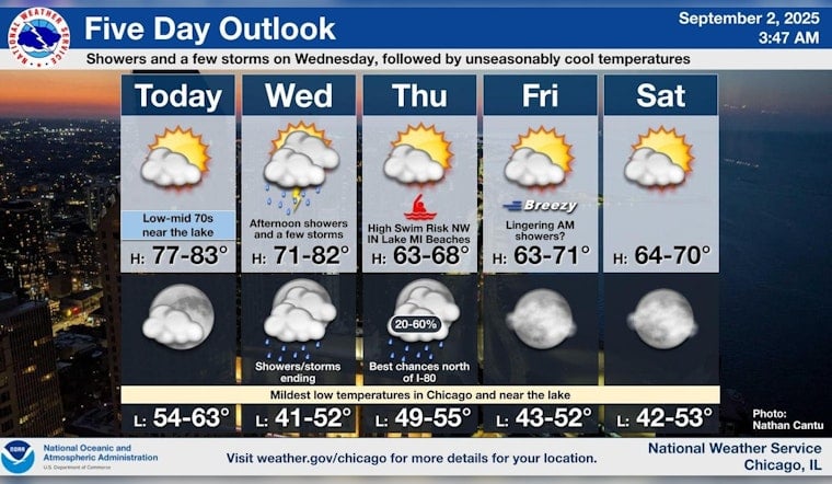
Chicago is set to experience a series of meteorological shifts this week, with a forecast that predicts sunny skies today, swiftly followed by stormy conditions and a dip in temperature. As reported by the National Weather Service, temperatures are anticipated to peak at 78 degrees today with modest easterly wind developments in the afternoon.
Despite the pleasant start, a significant change looms overhead. As the east wind tonight settles to a soft breeze, granting Chicagoans a mild evening with lows around 62, a cold front is expected to sweep through on Wednesday, according to FOX 32 Chicago. Forecasts herald showers and the potential for thunderstorms after 1:00 p.m., with the temperature grudgingly climbing to the mid-70s, pleasantries shared briefly with the sun before relinquishing their reign to the approaching storm.
Post-storm clarity isn't forecasted to last, despite the NWS indicating a near 50% probability of precipitation easing off before the night's end. The storm's departure ushers in clearer skies with a cooler temperature imprint, dropping to approximately 50 degrees. The subsequent days promise a touch of sunlight but buffer against complacency with the risk of occasional showers, particularly following Thursday's integration of drier air and gentler climates.
The weekend, however, does paint a more consistent picture, promising Chicago residents a reprieve from the rain. Temperatures will be nestling comfortably in the crisp empyrean of the upper 60s, flirting with the cusp of 70 degrees as reported by FOX 32 Chicago. As skies clear up Friday afternoon, inadvertently brought by a weak storm system, a reinforcing shot of cool air that lingers, hopes of amiable conditions ascend for the weekend.
Looking ahead, Monday's outlook aims to sustain the sunny trend set for Sunday, with highs projected to bloom near 70 degrees.


