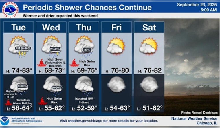
Residents in the Chicago area, brace yourselves for a dance of sun and rain this week. According to a forecast from the National Weather Service, today presents a chance of showers and thunderstorms after 1pm with highs teetering near 78 degrees – and don’t be fooled by the morning calm, winds will shift from south southwest to a more assertive north northeast in the afternoon. Be prepared for a slight chance of showers, then a chance of showers and thunderstorms, as stated in the area's weather forecast.
The on-and-off pattern continues into the night, with cloudy conditions and a low around 64 degrees, winds persisting from the north northeast. If you hoped for reprieve, Wednesday might disappoint with a 30 percent chance of mostly cloudy skies, and slightly cooler temps with a high near 70. Those gusts, though not as strong as today, could still reach up to 20 mph.
Looking further into the week, "The chance for rain sticks around on Thursday," according to a report from FOX32 Chicago. Expect partly sunny skies, and with the mercury inching towards a comfortable 71 degrees, though you might still want to keep your umbrella at the ready.
However, the forecast isn't all gray skies: Friday marks the beginning of a sunny respite, stretching clear through to Monday. Highs will climb back to the upper 70s by Friday, with the weekend hinting at temperatures that may kiss the 80-degree mark, paving the way for some much-deserved sunny reprieve. "This weekend will be warmer under the sunshine!" and indeed, balmy weather seems to invite Chicagoans to outdoor activities once the showers subside.


