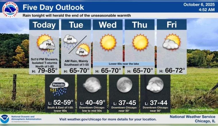
Chicagoans can expect a diverse array of weather conditions, starting with today's warm climate, before a cold front moves in, potentially leading to showers and thunderstorms, according to the National Weather Service. The warmth of the day is fleeting, poised to peak near 83 degrees, with a 30 percent chance of late showers and storms after 4 p.m. The winds are blowing south-southwest at around 10 mph, occasionally gusting up to 20 mph.
As the evening descends, so too does the likelihood of rainfall with a 70% chance of precipitation, the night forecast to be cloudy harboring likely showers and possibly a thunderstorm after 7 p.m. with a temperature hovering around a low of 61 degrees, the winds taking a northern turn at 5 to 10 mph gusting as high as 15 mph, and rainfall could measure between a quarter and half of an inch, as detailed by the National Weather Service.
The potential for rain seems to hold steady into early Tuesday, with a chance of showers and thunderstorms before 10 a.m., but the likelihood then tapers to a mere slight chance between 10 a.m. and 1 p.m. before skies are expected to clear. Despite a cooler air mass settling in, bringing Tuesday's highs down to the upper 60s, the rest of the week promises a respite, FOX 32 Chicago reports.
From Wednesday on, residents are in for a series of mostly sunny days, with highs anchoring themselves in the mid 60s on both Wednesday and Thursday but edging up to nearly 70 by Friday it's a pattern set to continue through to the weekend, featuring full sunshine and highs cresting in the mid 70s, making it an inviting forecast for those planning outdoor activities or just enjoying the crisp onset of fall in the Windy City.


