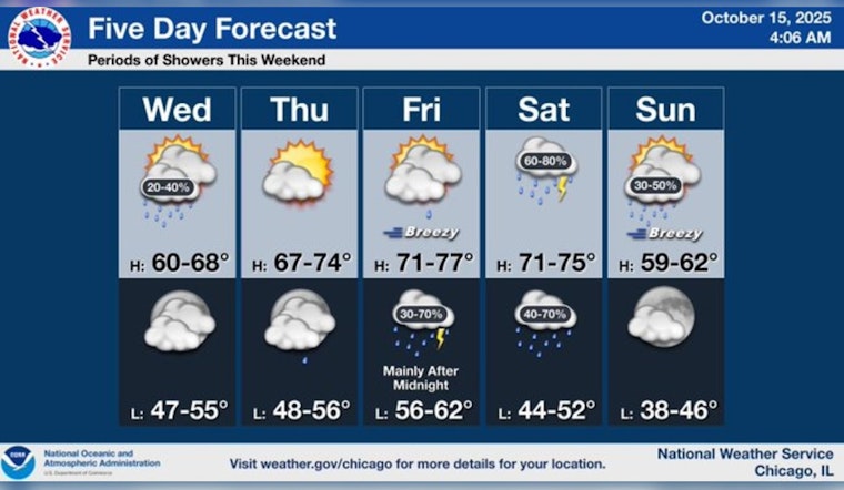
Chicago's weather today began with scattered showers, but they were expected to clear by late morning. According to the National Weather Service, the city saw a high near 61 degrees early in the day before the temperature began to steadily drop to the upper 50s in the afternoon. Cloud coverage remained heavy with some breaks of sun later in the day.
The brief dampness will give way to a warmer trend starting tomorrow with mostly sunny skies and highs hovering near the 70-degree mark. However, this upward shift is expected to quickly make a turn as a cold front pulls through over the weekend. "A 50 percent chance of showers and thunderstorms after 1am," for Friday night was forecasted, with Saturday likely to see an 80 percent chance of precipitation, as detailed by the National Weather Service.
In line with this, FOX 32 Chicago reported the cooling trend will persist throughout the afternoon, but the city will start to warm up again as we head towards the end of the week. By Friday, temperatures may escalate to the mid 70s, though this will be followed by potential showers leading into what could be "a fairly rainy day" on Saturday, with the thermometer peaking in the lower 70s.
As the cold front moves out, Sunday might still carry to show a chance for showers, with cooler highs in the low 60s. Sunny spells should grace the start of next week, giving Chicagoans a seasonable Monday, before yet another temperature climb on Tuesday. This warm-up is set to bring temperatures back around 70 degrees, although it also comes partnered with another possibility of showers, as reported by FOX 32 Chicago.


