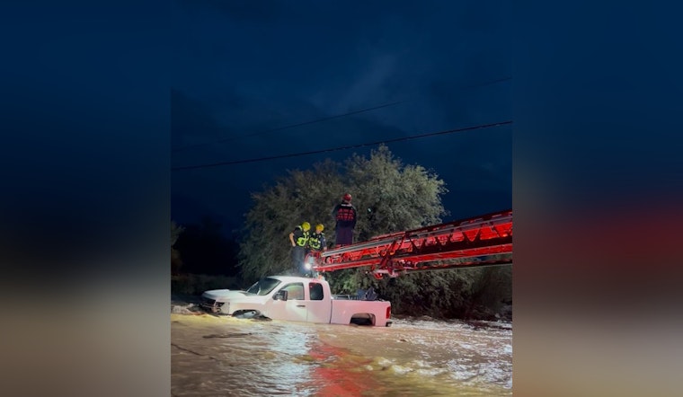
As heavy rain continues to besiege the Valley, Sunday’s storms brought substantial rainfall, causing a string of water rescues and road closures throughout Phoenix and surrounding areas; Buckeye emergency responders executed water rescues between the early hours of 4:30 and 5:30 a.m., with one individual rescued from swift-moving waters near Old US 80 and Patterson Road, while two people were saved using a ladder truck after their vehicle became trapped near Tuthill Road and Clara Vista, officials told ABC15.
In an effort to remind residents of the dangers of flooded roadways, Buckeye officials emphasized the significance of the “Turn Around, Don’t Drown” campaign, following the incidents where vehicles were seen stuck in floodwaters along 52nd Street south of University Drive, and a Dial-A-Ride van was thankfully extracted without injuries near 19th Avenue and Dobbins Road, the Phoenix Fire Department reported to ABC15; the Maricopa County Sheriff's Office continues to search for a man whose truck was swept away in floodwaters near 214th Avenue and Narramore Road, with the vehicle found but the man still missing.
The National Weather Service (NWS) forecasts one more day of treacherous rain that could lead to more flash flooding, keeping a flood watch in effect until 8 p.m. Monday, Gabriel Lojero from the NWS shared concerns about the heightened risk with KTAR News 92.3 FM, explaining that "Given how saturated the soils is, any heavy rainfall that flows will become instantaneous runoff," adding that as little as 1/2 to 3/4 of an inch of precipitation could trigger flash flooding.
This onslaught of rain led to Phoenix's rainiest day since 2018 on Sunday, registering an impressive daily record of 1.97 inches at the Phoenix Sky Harbor International Airport, which amassed a total of 3.06 inches since Thursday, such totals contribute to significant dampness within the soil resulting in instantaneous runoff even with lesser rainfall amounts - preparing the region for further flooding if the downpours continue as predicted, according to data from the Maricopa County Flood Control District map reported by KTAR News 92.3 FM.
The extended forecast, however, offers a glimpse of reprieve; Lojero told KTAR News 92.3 FM that "We're going to have much drier air moving in as we head into this evening and into Tuesday," which is expected to put an end to the current rain cycle, resulting in more moderate temperatures throughout the rest of the week, hinting at a resumption of daily norms after Monday’s showers dissipate.


