Chicago woke up shivering on Thursday, February 5, 2026, with raw, sub-freezing air, temperatures near 18°F, and gusty southwest winds. Scattered snow showers are on tap from late morning into the afternoon, and forecasters are already eyeing an overnight shift that could flip to freezing drizzle or a wintry mix, setting up a slick start for parts of Friday's morning commute.
What To Expect Today
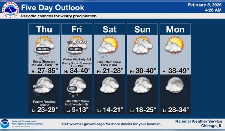
Scattered snow showers are expected between about 9 a.m. and 3 p.m. Thursday, February 5, with a high near 30°F and south-southwest winds of 10-15 mph, gusting to around 25 mph. Most spots should see only light accumulation, with less than a half inch of new snow possible, but brief bursts could quickly knock down visibility on surface streets, according to the National Weather Service Chicago.
Earlier Forecasts And The Skinny Band
Earlier this week, forecasters tracked a narrow convective “skinny band” that fired off brief, intense bursts of snow in parts of the region. That same general setup means localized heavier showers remain on the table today, even if most of the city only sees mood flakes. Read our earlier skinny band coverage for where that band trended and how it behaved.
Overnight Into Friday: Freezing Mist And Wintry Mix
Overnight, there is a low-confidence risk for pockets of freezing mist or drizzle as low clouds sink and surface dew points creep up toward the cold ground. That setup could leave untreated parking lots and ramps briefly slick, even without dramatic radar returns.
A second, faster-moving system is expected to cross the area centered on the Friday morning commute, February 6, and could bring sleet and freezing rain between roughly 3 and 4 a.m. That would be enough to produce locally hazardous travel, even if overall ice amounts stay on the lighter side.
Friday Winds And Lake-Effect Snow
A sharp cold front is forecast to race through Friday evening, with northwest winds potentially gusting into the mid 30s mph. That will raise the chance of quick, squall-like snow bursts along the front and downwind of Lake Michigan.
Lake-effect snow showers are likely to linger into Friday night and Saturday across northwest Indiana. Impacts there are expected to be mainly a nuisance, but a few inches of snow could pile up in the usual favored corridors.
Travel And Safety Tips
If you have to drive, build in extra time, slow down on bridges and shaded ramps, and clear all snow and ice from your vehicle before pulling out. For basic winter driving guidance and up-to-date roadway resources across Illinois, check the Illinois Department of Transportation.
Forecasters will refine the timing and impacts through the day. Check local updates before heading out, and give yourself a little extra cushion Friday morning if your route takes you over untreated or low-lying surfaces.


