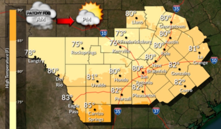
Austin is starting Friday, February 13, 2026, under a blanket of patchy dense fog, with temperatures around 62°F and some spots reporting visibility down to about a quarter mile. The murk should lift by mid-morning, letting the city warm into the low 80s with a high near 81°F. South-southeast winds are light for now but are expected to pick up later in the day, with gusts up to about 20 mph. Drivers should expect a slower-than-usual commute through roughly the 9 a.m. to 10 a.m. window.
Fog And The Morning Commute
The National Weather Service issued a Special Weather Statement early Friday, calling out patchy dense fog from the Hill Country through the I-35 corridor and toward the coastal plains. Forecasters warned that local visibilities could drop to one-quarter mile or less, with conditions expected to improve by about 9 a.m. Friday, February 13.
While the fog lingers, stick with low beams, ease off the gas, and leave extra room to brake, especially on highways and bridges where speeds are higher. If you are heading to Austin-Bergstrom before mid-morning, plan for extra drive time and check with your airline in case the low visibility triggers delays.
Saturday Storm Timeline And Rain Chances
Saturday, February 14, 2026, looks soggy, with rain showers likely arriving early and showers and thunderstorms becoming more widespread through the morning and afternoon. The forecast high is near 75°F, with about a 90% chance of precipitation and south winds that could gust up to around 25 mph. New rainfall amounts of roughly a quarter to a half inch are possible in some areas.
Most of the Austin metro should see only brief heavy downpours, but a few stronger storms could crank out higher localized totals and gusty winds. If you are planning outdoor time on Saturday, build in a rain backup or be ready to dodge thunderstorms between rounds.
Wind And Fire Weather Concerns West Of I-35
Forecasters are also flagging elevated to near-critical fire weather conditions from Saturday afternoon into Sunday for areas generally west of I-35 and I-37. Drier air and gusty winds there could boost fire risk even with some rainfall farther east.
Breezy northwest winds are expected Sunday into Monday, with above-normal temperatures hanging on through the rest of next week. If you live west of I-35, it is a good time to clear loose yard debris and follow any local burn restrictions. Public safety pages will push out additional updates if conditions trend worse.
Why This Update Matters
This forecast updates an earlier Hoodline outlook published on February 9, 2026, that focused on the warm stretch and recurring morning fog. Since then, a new Special Weather Statement and higher storm probabilities through Saturday have turned this into more of a heads-up situation for weekend plans.
For background on the warm pattern leading into this weekend, see the earlier Hoodline coverage on the February sizzle and near-85-degree heat. Keep an eye on updated forecasts if you have outdoor Valentine’s Day plans for Saturday evening.
Quick Tips
Delay nonessential travel before 9 a.m. Friday, if you can, and have a shelter plan ready for outdoor events Saturday night in case storms linger or redevelop. Stay tuned to the National Weather Service for any updated advisories, watches, or warnings as this system evolves.


