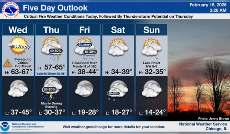
Chicago is waking up to a cloudy but surprisingly mild Wednesday, with temperatures already in the low 50s. Forecasters are calling for a high near 66°F this afternoon as humidity drops and southwest winds crank up. That mix of warm air, low relative humidity and gusty winds is raising fire-weather concerns across parts of the region.
Afternoon Winds Pick Up
Southwest winds are expected to ramp up through the afternoon, with sustained speeds of 15-25 mph and gusts that could reach 40-45 mph in parts of the area. The National Weather Service has issued a Red Flag Warning for locations along and west of the Fox Valley and I-55 from 10 AM to 8 PM, and a Wind Advisory is in place for portions of the region from 10 AM to 6 PM. The strongest gusts are anticipated over the western suburbs and northwest counties, with winds easing after sunset, according to NWS Chicago.
Fire Danger And Burning Rules
Low afternoon humidity combined with those gusty winds will create an elevated-to-critical fire-weather window this afternoon, particularly along and west of the Fox Valley and I-55 corridor. Outdoor burning is strongly discouraged, and residents are urged to hold off on burning yard waste or using open flames until conditions settle down. Open fires and most backyard burning are already unlawful inside the city, and violations can lead to fines, per the Chicago municipal code.
Late-Week Outlook
A storm system moves in Thursday, with rain likely and a chance of thunderstorms Thursday night before colder air sweeps in Friday and through the weekend. Highs will tumble back into the 30s and 40s by Friday, with breezy conditions hanging on through the day, according to NWS Chicago. We wrote about the warm stretch earlier this week in our look at the week's warm stretch, and this update zeroes in on the fire-weather and wind threats for Wednesday.


