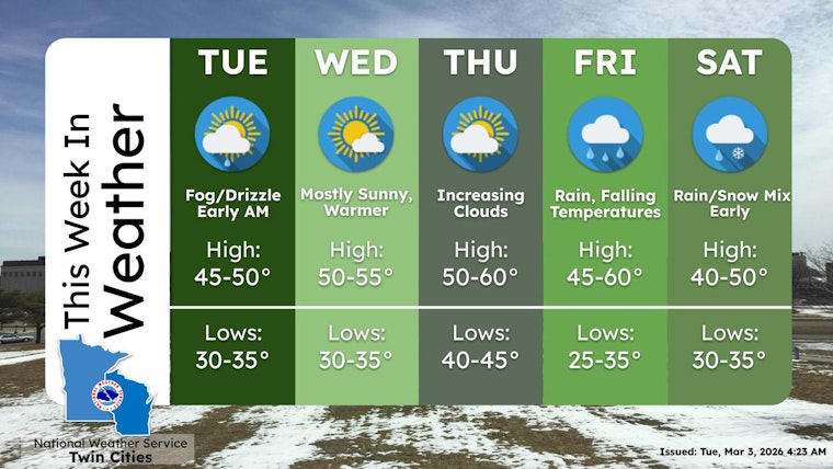
Minneapolis wakes up under a blanket of clouds this morning, with mid-30s temperatures and a light southerly breeze hinting at a change in the air. As the day wears on, skies should thin out and let in some sun, nudging highs into the upper 40s to around 50 and delivering the first sustained stretch of above-freezing weather in days. That milder pattern sticks around through Thursday before a wetter system muscles in later in the week.
Afternoon Sun and a Midweek Warmup
Afternoons through midweek look mostly sunny to partly cloudy, with highs near 50 on Tuesday and climbing into the low-to-mid 50s on both Wednesday and Thursday as a steady southerly flow settles in. Winds should stay on the gentle side, around 5 mph, which means you get the warmth without the windchill whiplash. The National Weather Service Twin Cities highlights this gradual warm-up and the lower odds for precipitation through midweek, and notes there are no active watches or warnings for the metro right now.
Rain Likely Late Friday Into Saturday
A stronger storm system is on track to arrive late Friday, likely bringing at least two rounds of rain and giving the area its best shot at measurable precipitation. Forecasters expect rainfall totals from Friday into Saturday to range between a few tenths of an inch and an inch or more, with some spots possibly pushing close to an inch. Parts of western and central Minnesota could see a rain and snow mix overnight into Saturday as the system moves through. This forecast sharpens and expands on our March 1 coverage; see our March 1 forecast for the earlier outlook.
What This Means for Your Commute
From Tuesday through Thursday, drives and bus rides should mostly be dry, although melting snow may leave some slushy stretches on sidewalks and expose fresh potholes. By Friday evening, the incoming rain could slow traffic, create standing water in low spots, and raise the risk of hydroplaning on untreated pavement, so it is worth budgeting a little extra time. If your weekend involves outdoor plans, plan on a waterproof layer and be ready for damp conditions on Saturday morning.
Looking Ahead
Temperatures are expected to bounce back into the upper 50s by Sunday, keeping the mild trend going into early next week. The overall pattern stays active, though, with additional systems likely lining up behind this one. For any timing changes and the latest details, check in with the National Weather Service Twin Cities and local transit rider alerts before you head out.


