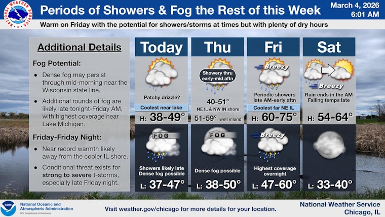
Chicago woke up socked in on Wednesday, March 4, 2026, as dense fog poured into the city and suburbs, cutting visibility on major streets and interstates and raising the risk of slick patches in colder inland spots. Morning temperatures sit in the upper 30s, with an afternoon high near 40°F and a slight chance of light rain toward the late afternoon. East-northeast winds will stay on the lighter side, and the onshore flow off Lake Michigan will keep lakeside neighborhoods a few degrees cooler than inland areas. By Friday, March 6, that cool, gray setup flips hard, with highs expected to surge into the 60s ahead of a cold front.
Fog And The Morning Commute
A Dense Fog Advisory is posted through 9 AM CST Wednesday, March 4, 2026, for portions of northern Illinois, where visibility may drop to a quarter mile at times, especially near the Wisconsin line, according to the National Weather Service Chicago. Drivers are urged to slow down, stick with low beams or fog lights, and budget extra time for ramps and bridges that can pick up patchy, slick spots. Transit riders should be ready for slower travel and some spacing of buses and trains while the fog hangs on.
Afternoon: Mostly Cloudy With A Small Shower Chance
Most neighborhoods should stay mostly cloudy through the afternoon, with highs around 40°F and readings gradually sliding back into the upper 30s later in the day. A stray rain shower or bit of drizzle could pop up after about 3 PM on Wednesday, March 4, although most areas are expected to stay dry through the afternoon. East-northeast winds will run around 5 to 10 mph, enough to keep the lakefront feeling noticeably cooler than inland communities.
Tonight Into Thursday: Showers And More Fog
Rain coverage is expected to increase tonight into Thursday, March 5, with periods of showers and areas of fog that could again cut down overnight visibility. New rainfall totals of about a tenth to a quarter of an inch are possible. Thursday’s high will be near 43°F, and a few thunderstorms cannot be ruled out in the morning, where pockets of heavier rain set up. Fog may redevelop Thursday night into Friday morning as southerly flow strengthens ahead of a warm front.
Late-Week Warm-Up And Storm Watch
By Friday, March 6, Chicago is on track for a rapid warm-up, with inland highs jumping into the mid 60s and south-southwesterly wind gusts potentially reaching about 30 mph, which is near record territory for early March. Showers and scattered thunderstorms are expected Friday, followed by more widespread showers and storms late Friday night into Saturday. Some storms could become strong to severe, although confidence in that threat remains low for now. We covered the evolving warm surge in our March 3 update; see our big warmup breakdown for background and prep tips.
What To Do
For the rest of the morning, handle the reduced visibility like a winter commute: ease off the gas, turn on the headlights, and give yourself extra space from the car ahead. If you have outdoor plans from Friday night into Saturday morning, keep a close watch on updates and have an indoor fallback ready in case thunderstorms move in, and secure loose outdoor items before the gusty winds arrive Friday. For the latest watches and advisories, follow the National Weather Service and local transit alerts.


