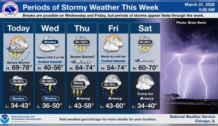
Chicago rolled into Tuesday, March 31, 2026, feeling more like late spring than early April, with mild temperatures in the mid‑60s and mostly clear skies to start the day. That calm will not stick around for long. A strong cold front is on track to sweep across the region today, dragging a line of showers and thunderstorms through the metro area this afternoon and evening. Once the front passes, expect a sharp temperature drop, especially right along the lakefront, so plan on a big weather mood swing by tonight.
Showers And Thunderstorms Likely Midday
Scattered showers and thunderstorms are possible before 9 a.m., with storms becoming more likely between about 9 a.m. and noon and additional rounds possible through the afternoon. Highs should top out near 71°F before readings slide back into the 50s and 60s later in the day. Southwest to west‑southwest winds around 15 to 20 mph are expected ahead of the front, with gusts up to around 30 mph and potentially stronger in the most intense storms. According to the National Weather Service in Chicago, the best chance for stronger or severe storms this afternoon and evening is southeast of I‑55, with the primary concerns being damaging winds, isolated hail and locally heavy downpours.
Afternoon Commute And Outdoor Plans
Travel could slow down where the heaviest showers and storms roll through, with brief drops in visibility and ponding in low‑lying spots during stronger cells. If you have outdoor events, youth sports or rooftop dining on the calendar, build in an indoor backup plan for late afternoon and early evening, and secure patio furniture or other loose items before midday. Check CTA, Metra and local transit alerts and give yourself extra time on the roads if you need to be out during the evening rush.
Lakefront And Boaters
A Small Craft Advisory remains in effect for Illinois and Indiana nearshore waters through Wednesday evening. Choppy, building waves and shifting winds will make Lake Michigan hazardous for smaller boats. Recreational boaters and sailors are urged to stay in port until conditions improve and to follow marine forecasts closely if travel on the lake is unavoidable.
Looking Ahead
The unsettled pattern is expected to hang around into the weekend, with additional rounds of showers and thunderstorms possible on Thursday and again from Friday night into Saturday. There is a growing concern for pockets of heavy rain and localized flooding where storms repeatedly move over the same areas. Temperatures should rebound briefly on Thursday before turning noticeably cooler for Easter Sunday, April 5, when highs are projected to land in the 40s to low 50s. For more on the broader setup behind this stretch of active weather, check out our earlier coverage of Chicago's wild weather roller coaster.


