Chicago started Saturday soggy and socked-in, with light rain and fog lingering across the city and Midway sitting near 61°F with murky visibility. The quiet, gray vibe will not last long, as showers and thunderstorms are expected through the early afternoon before a cold front sends temperatures tumbling into the mid-40s by late day.
Showers and Thunderstorms: Timing and Impacts
Scattered showers and thunderstorms are likely before 2 p.m. today (Saturday, March 7, 2026), with an 80% chance of precipitation and new rainfall amounts generally under a tenth of an inch, according to the National Weather Service Chicago. Expect west-southwest winds at 15 to 20 mph with gusts up to 30 mph. Many spots will hit their daytime high near 61°F before the cold front barges through and knocks readings into the mid-40s.
Afternoon Winds Pick Up
The cold front will usher in gusty west-to-northwest winds this afternoon. Forecasters noted peak gusts over 50 mph were observed farther west and say locally strong to damaging gusts remain possible. A Small Craft Advisory is in effect for Illinois and Indiana nearshore waters through noon CST, which means choppy, hazardous conditions on Lake Michigan. Secure loose patio furniture, trash bins, and decorations, and use extra caution on bridges and ramps during the strongest gusts.
What Changed From Friday
On Friday the big story was limited visibility, with dense fog and a Dense Fog Advisory blanketing parts of the area. Today the focus shifts to the passing front and its gust potential as the system moves across the region. Check out the foggy morning setup for more on how we got here and the earlier timing.
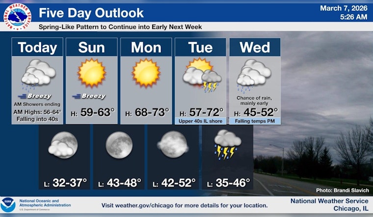
Looking Ahead
Sunday should be drier and breezy with highs near 61°F, and Monday looks even milder with highs in the mid-60s. Another, more widespread system arrives Tuesday into Wednesday with likely rain, a risk for heavy thunderstorms, and localized flooding in spots. Colder air may briefly flip rain to snow in the far northern suburbs before the system exits.
How To Prepare
Plan on layers and an umbrella for the afternoon commute, and give yourself extra travel time where radar shows heavier downpours. If you are heading toward the lake, follow the Small Craft Advisory guidance and hold off on launching small vessels until conditions calm down.


