Apple Creek woke up wondering whether Tuesday night’s wild weather was just a nasty line of storms or something more serious.
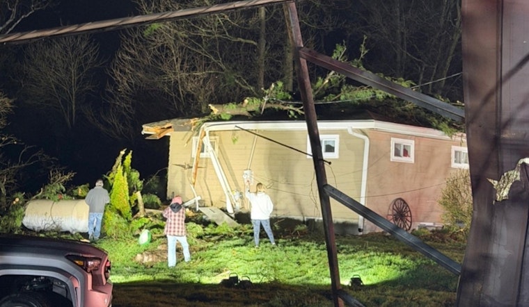
The National Weather Service is sending a storm-survey team to the Apple Creek area of Wayne County after severe storms ripped through the region Tuesday night. Local crews reported downed trees and property damage, and utility companies said thousands lost power across northeast Ohio. Officials said the on-site survey will determine whether any of that damage came from a tornado.
As reported by WKYC, the agency plans to inspect storm damage specifically in the Apple Creek area. The National Weather Service leans on detailed field work to figure out what really happened when storms turn ugly.
Its survey playbook, outlined in NCEMA’s “The Art of Surveying Tornado and Straight-Line Wind Damage,” explains how crews walk damaged areas, talk to residents, and document what they see “to find out exactly what happened.” Those findings help sharpen future warnings and build a long-term record of severe weather in each community.
How Crews Tell A Tornado From Straight-Line Wind
Survey teams are basically storm detectives. One of the biggest clues they look for is how the debris is arranged.
If trees and debris are tossed toward each other in a convergent pattern, that usually points to a tornado. If everything is thrown in the same general direction, that is more typical of straight-line wind.
To estimate how strong the winds were, crews compare damage to benchmarks on the Enhanced Fujita scale. The Storm Prediction Center notes that EF-0 damage lines up with roughly 65 to 85 mph winds, while EF-1 corresponds to about 86 to 110 mph. The more structures and trees they can inspect, the more confident they can be about where the storm falls on that scale.
Local Impacts
Tuesday’s storms did not just rattle windows. They knocked out power across a wide swath of Northeast Ohio. News 5 Cleveland reported that nearly 200,000 customers were still offline after the system moved through.
In Wayne County, local fire crews responded to a home on the 5700 block of South Honeytown Road after a tree came crashing down, according to WKYC. Scenes like that will be key stops for the survey team.
What Happens Next
Storm-survey crews typically drive from one damage point to the next, take photos and measurements, and log what type of structures or trees were hit. After that, they head back to the office, compare notes, study radar and satellite data, and put together a final assessment.
That full process can take anywhere from a few hours to several days, depending on how widespread the damage is, how easy it is to access each site, and whether more storms are in the forecast.
The National Weather Service also urges residents who safely captured photos or video of the damage to share them with local emergency management and the weather office. Those extra angles can help fill in gaps and make the final survey as accurate as possible.


