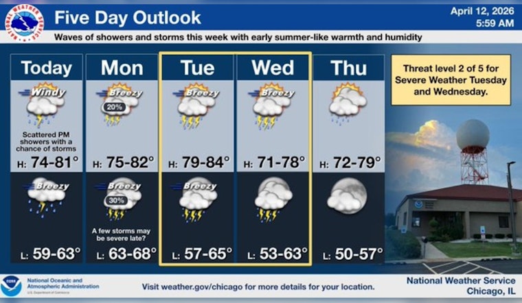
As of 6:35 a.m. CDT Sunday, April 12, 2026, skies are mostly clear over Chicago and temperatures are sitting near 61°F, but that will not last long. A warm, humid airmass is moving in, sending afternoon highs toward 78°F and setting the stage for isolated showers early this afternoon and a higher chance of showers and thunderstorms tonight.
Afternoon Winds And Lake Conditions
South-southwest winds are expected to crank up to 15 to 30 mph this afternoon, with gusts that could reach 45 mph, especially along the lakefront and on exposed bridges. The National Weather Service has issued Small Craft Advisories for the nearshore waters this morning and a Gale Warning for the Illinois and Indiana nearshore waters from noon into the evening, so boaters should brace for hazardous conditions. On land, it is a good day to secure patio furniture, keep a firm grip on umbrellas, and think twice about exposed driving routes during peak gusts, particularly along Lake Shore Drive, according to the National Weather Service.
Showers, Storms Tonight And Midweek
Showers and thunderstorms are likely tonight, mainly before 3 a.m. Monday, April 13, 2026. The overnight rain chance is elevated, with new rainfall totals between a quarter and a half inch possible in heavier cells. Temperatures stay mild with a low near 63°F tonight as the warm, humid pattern carries into next week. Forecasters are eyeing Tuesday and Wednesday, April 14 to 15, 2026, as the main windows for stronger storms that could bring damaging winds, hail, and heavy downpours capable of triggering localized flooding.
What To Know For Your Commute
Plan on a slower-than-usual trip this afternoon and again tonight. Gusty crosswinds on bridges and lakefront routes, along with pockets of heavy rain, could make driving tricky. We flagged a similar setup on April 2; check out our earlier wind whiplash breakdown for more details and practical safety tips.


